Platißbach
| Platißbach | |
|---|---|
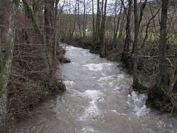 Platißbach by the campsite | |
| Location | Eifel, North Rhine-Westphalia, Euskirchen |
| Reference no. | DE: 282284 |
| Physical characteristics | |
| Main source |
northwest of Hollerath ca. 605 m above sea level (NHN) 50°27′59″N 6°22′08″E / 50.46639°N 6.36879°ECoordinates: 50°27′59″N 6°22′08″E / 50.46639°N 6.36879°E |
| River mouth |
in Hellenthal into the Olef ca. 403 m above sea level (NHN) 50°29′30″N 6°26′18″E / 50.49171°N 6.43830°E |
| Length | 7.416 km [1] |
| Basin features | |
| Progression | Olef→ Urft→ Rur→ Meuse→ North Sea |
| Basin size | 38.564 km² [1] |
The Platißbach is a roughly seven-kilometre-long, southern and orographically right-hand tributary of the River Olef in the municipality of Hellenthal in Germany.
Course
The Platißbach rises in the High Fens-Eifel Nature Park in the North Eifel natural region of the Hollerath Plateau. Its source lies about 2.5 kilometres northwest of the village of Hollerath and one kilometre north of the Belgian border at a height of about 605 m.
The Platißbach initially flows in a northern direction. After about a kilometre it collects an unnamed stream from the left and changes direction to head east. On reaching the B 265 it changes course again and flows parallel to the road in a northwesterly direction to its mouth. On its way it flows through the Platißbach Valley Nature Reserve.[2] The Platißbach picks up other tributaries from both sides, near Platiß, the only village it passes , at a height of about 422 m, it is joined by its main tributary, the Prether Bach. In Hellenthal it empties into the Urft tributary, the Olef, at about 403 m.
Catchment and tributaries
The catchment of the Platißbachs is 38.6 km² in area and drains over the Olef, Urft, Rur, Meuse and Hollands Diep into the North Sea.
| Name[1] | Left/right tributary | Length [km][1] | Catchment [km²][1] | Distance from mouth [km][3] | GKZ[1] |
|---|---|---|---|---|---|
| Kaisersiefen | right | 0.5 | 5.4 | 282284-112 | |
| Eschsiefen | right | 2.4 | 4.6 | 282284-12 | |
| Langersiefen | right | 2.1 | 4.1 | 282284-14 | |
| Kammersiefen | left | 1.1 | 3.8 | 282284-16 | |
| Mehlensiefen | left | 1.0 | 3.5 | 28228418 | |
| Prether Bach | right | 10.2 | 24.893 | 2.1 | 282284-2 |
| Drees Bach | right | 1.6 | 1.1 | 282284-94 | |
| Speissiefen | left | 1.2 | 0.5 | 282284-96 |
References
- 1 2 3 4 5 6 Hydrographic Directory of the NRW State Office for Nature, the Environment and Consumer Protection (Gewässerverzeichnis des Landesamtes für Natur, Umwelt und Verbraucherschutz NRW 2010) (xls; 4.67 MB)
- ↑ Platißbachtal Nature Reserve in the information system of the NRW State Office for Nature, the Environment and Consumer Protection.
- ↑ Measurement based on German terrain maps (Deutscher Grundkarte) 1:5000 series