Plate Boundary Observatory
The Plate Boundary Observatory (PBO) is the geodetic component of the EarthScope Facility. EarthScope is an earth science program that explores the 4-dimensional structure of the North American Continent.[1] EarthScope (and PBO) is a 15-year project (2003-2018) funded by the National Science Foundation in conjunction with the NASA. PBO construction (an NSF MREFC) took place from October 2003 through September 2008.[2] Phase 1 of operations and maintenance concluded in September 2013. PBO is currently in phase 2 of operations, which will end September 2018.
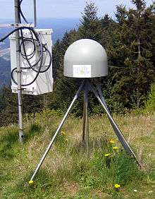
PBO precisely measures Earth deformation resulting from the constant motion of the Pacific and North American tectonic plates in the western United States. These Earth movements can be very small and incremental and not felt by people, or they can be very large and sudden, such as those that occur during earthquakes and volcanic eruptions. The high-precision instrumentation of the PBO enables detection of motions to a sub-centimeter level. PBO measures Earth deformation through a network of instrumentation including: high-precision Global Positioning System (GPS) receivers, strainmeters, seismometers, tiltmeters, and other geodetic instruments. The GAGE Facility (Geodesy Advancing Geosciences and EarthScope), operated by UNAVCO, Inc., is responsible for instrument installation, ongoing maintenance, communications, data archiving, data processing, and data availability for the instrumentation. UNAVCO is a non-profit university-governed consortium that facilitates geoscience research and education using geodesy.
The PBO GPS network includes 1100 stations extending from the Aleutian Islands south to Baja and eastward across the continental United States. During the construction phase, 891 permanent and continuously operating GPS stations were installed, and another 209 existing stations were integrated (PBO Nucleus stations) into the network. Geodetic imaging data is transmitted, often in realtime, from a wide network of GPS stations, augmented by seismometers, strainmeters and tiltmeters, complemented by InSAR (interferometric synthetic aperture radar), LiDAR (light-activated radar), and geochronology.
The GPS stations are categorized into clusters. The transform cluster is near the San Andreas Fault in California; the subduction cluster is in the Cascadia subduction zone (northern California, Oregon, Washington, and southern British Columbia); the extension cluster is in the Basin and Range region; the volcanic cluster is in the Yellowstone caldera, the Long Valley caldera, and the Cascade volcanoes; the backbone cluster is at 100–200 km intervals across the United States to provide complete spatial coverage.
Data from the PBO is transmitted to UNAVCO to the data center where it is collected, archived and distributed. These data sets are freely and openly available to the public, with equal access provided for all users. PBO data includes the raw data collected from each instrument, quality-checked data in formats commonly used by PBO's various user communities, and processed data such as calibrated time series, velocity fields, and error estimates.
Some scientific questions that are being addressed by the EarthScope project and the PBO include:[3]
- How does accumulated strain lead to earthquakes?
- Are there recognizable precursors to earthquakes?
- How does the evolution of the continent influence the motions that are happening today?
- What happens to geologic structures at depth?
- What influences the location of features such as faults and mountain ranges?
- Is it inherited from earlier tectonic events or related to deeper processes in the mantle?
- How is magma generated? How does it travel from the mantle to reach the surface?
- What are the precursors to a volcanic eruption?[4]
References
- ↑ EarthScope. EarthScope. http://www.earthscope.org/. Missing or empty
|title=(help); Missing or empty|url=(help);|access-date=requires|url=(help) - ↑ UNAVCO (2009). Plate Boundary Observatory: The first five years. p. 10.
- ↑ Williams, M.L., K.M. Fische r, J.T. Freymuelle r, B. Tikoff, A.M. T réhu; et al. (February 2010). Unlocking the Secrets of the North American Continent: An EarthScope Science Plan for 2010-2020, (PDF). p. 78.
- ↑ National Research Council, Review of EarthScope Integrated Science (Washington D.C., National Academy Press, 2001).