Pléneau Island
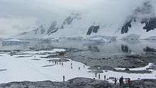
Tourists visit Pléneau Island
Pléneau Island (65°6′S 64°3′W / 65.100°S 64.050°WCoordinates: 65°6′S 64°3′W / 65.100°S 64.050°W) is an island, 0.8 nautical miles (1.5 km) long, lying just northeast of Hovgaard Island in the Wilhelm Archipelago. Charted as a peninsula of Hovgaard Island by the French Antarctic Expedition, 1903–05, under J.B. Charcot, who named its northeast point for Paul Pléneau, photographer of the expedition. The feature was first shown to be an island on an Argentine government chart of 1957.
 Tourist with Gentoo penguins on Pléneau Island
 Kayakers around Pléneau Island
 Gentoo penguin on Pléneau Island
 Gentoo penguin and chicks on Pléneau Island
 Gentoo penguin colony on Pléneau Island
 Kayaker photographs Gentoo penguins on Pléneau Island
 Scientist counts Gentoo penguins on Pléneau Island
 Pléneau Island
See also
References
![]()
Further reading
This article is issued from
Wikipedia.
The text is licensed under Creative Commons - Attribution - Sharealike.
Additional terms may apply for the media files.