Hovgaard Island
 Hovgaard Island | |
 Hovgaard Island Antarctic Peninsula | |
| Geography | |
|---|---|
| Location | Antarctica |
| Coordinates | 65°7′S 64°4′W / 65.117°S 64.067°WCoordinates: 65°7′S 64°4′W / 65.117°S 64.067°W |
| Archipelago | Wilhelm Archipelago |
| Administration | |
| Administered under the Antarctic Treaty System | |
| Demographics | |
| Population | Uninhabited |
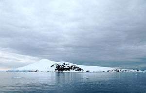
Hovgaard Island is an island 6 km (3 nmi) long, lying off the northwest coast of Kiev Peninsula, 2.8 km (1.5 nmi) southwest of Booth Island in the Wilhelm Archipelago, Antarctica.
It was discovered and named "Krogmann-Insel" (Krogmann Island) by the German 1873–74 expedition under Eduard Dallmann, but the name Hovgaard, after Polar explorer and officer of the Danish Navy Andreas Hovgaard,[1] applied by the Belgian Antarctic Expedition, 1897–99, under Gerlache, has overtaken the original name in usage. The name Krogmann Point has been given to the western extremity of Hovgaard Island.[2]
Hovgaard Island is a popular location for camping in Antarctica among expedition groups due to the presence of a relatively flat campsite along Penola Strait. Campers dig "snow graves" to sleep in. The holes offer protection from the wind.[3]
See also
References
- ↑ Hovgaard Ø. In: Anthony K. Higgins: Exploration history and place names of northern East Greenland. Geological Survey of Denmark and Greenland Bulletin Bd. 21, 2010. Copenhagen 2010, ISBN 978-87-7871-292-9
- ↑ "Hovgaard Island". Geographic Names Information System. United States Geological Survey. Retrieved 2012-06-29.
- ↑ Camping on Hovgaard Island -- TravelPod
 Campers on Hovgaard Island
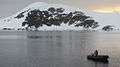 Hovgaard Island, Antarctica
 Campers on Hovgaard Island
 Campers on Hovgaard Island
 Campers on Hovgaard Island
![]()