Pizzo di Gino
| Pizzo di Gino | |
|---|---|
 | |
| Highest point | |
| Elevation | 2,245 m (7,365 ft) |
| Prominence | 367 m (1,204 ft) [1] |
| Coordinates | 46°07′24″N 9°08′43″E / 46.12333°N 9.14528°ECoordinates: 46°07′24″N 9°08′43″E / 46.12333°N 9.14528°E |
| Geography | |
 Pizzo di Gino Location in the Alps | |
| Location | Lombardy, Italy |
| Parent range | Lugano Prealps |
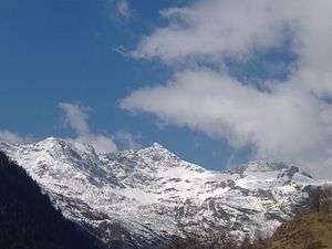
Pizzo di Gino is a mountain of Lombardy, Italy. With an elevation of 2,245 m it is the highest peak of the Lugano Prealps.
SOIUSA classification
According to the SOIUSA (International Standardized Mountain Subdivision of the Alps) the mountain can be classified in the following way:[2]
- main part = Western Alps
- major sector = North Western Alps
- section = Lugano Prealps
- subsection = Prealpi Comasche
- supergroup = Catena Gino-Camoghè-Fiorina
- group = Gruppo del Gino
- code = I/B-11.I-A.1
Access to the summit
The easiest route for the summit starts from San Nazzaro Val Cavargna and passes by a mountain hut called Rifugio Croce di Campo (1,739 m).[3]
Notes
- ↑ Retrieved from the Swisstopo topographic maps. The key col is the Bocchetta di Nembruno (1,878 m)
- ↑ Marazzi, Sergio (2005). Atlante Orografico delle Alpi. SOIUSA (in Italian). Priuli & Verlucca. ISBN 978-88-8068-273-8.
- ↑ Pizzo di Gino - 2245 m, web page on www.vienormali.it (accessed on 2012-04-05)
External links
This article is issued from
Wikipedia.
The text is licensed under Creative Commons - Attribution - Sharealike.
Additional terms may apply for the media files.