Pizzo di Cassimoi
| Pizzo di Cassimoi | |
|---|---|
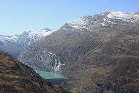 Pizzo di Cassimoi (far left) from above Zervreilasee | |
| Highest point | |
| Elevation | 3,129 m (10,266 ft) |
| Prominence | 242 m (794 ft) [1] |
| Parent peak | Rheinwaldhorn |
| Coordinates | 46°31′44″N 9°01′05″E / 46.52889°N 9.01806°ECoordinates: 46°31′44″N 9°01′05″E / 46.52889°N 9.01806°E |
| Geography | |
 Pizzo di Cassimoi Location in Switzerland | |
| Location | Ticino/Graubünden, Switzerland |
| Parent range | Lepontine Alps |
Pizzo di Cassimoi is a mountain of the Lepontine Alps, located on the border between the Swiss cantons of Ticino (west) and Graubünden (east). The mountain overlooks two lakes: Lago di Luzzone on its north-eastern side and Zervreilasee on its north-eastern side.
A glacier named Vadrecc di Sorda lies over the northern flanks below a secondary summit (Pizzo Cassinello, 3,103 metres) on the side of Ticino.
Position on map http://map.geo.admin.ch/
References
External links
This article is issued from
Wikipedia.
The text is licensed under Creative Commons - Attribution - Sharealike.
Additional terms may apply for the media files.