Pizzo Forno
| Pizzo Forno | |
|---|---|
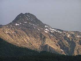 Pizzo Forno, June 2005 | |
| Highest point | |
| Elevation | 2,907 m (9,537 ft) |
| Prominence | 253 m (830 ft) [1] |
| Parent peak | Pizzo Campo Tencia |
| Coordinates | 46°25′58.6″N 8°46′36.7″E / 46.432944°N 8.776861°ECoordinates: 46°25′58.6″N 8°46′36.7″E / 46.432944°N 8.776861°E |
| Geography | |
 Pizzo Forno Location in Switzerland | |
| Location | Ticino, Switzerland |
| Parent range | Lepontine Alps |
Pizzo Forno is a mountain of the Swiss Lepontine Alps, overlooking Chironico in the canton of Ticino. It is to be found between Piumogna Valley, Chironico Valley and Leventina Valley. It is in pyramid form and is separate from Pizzo Campo Tencia in the east. It is visible from the municipalities of Faido, Giornico and Chironico. The north-east face is particularly striking which rises nearly 1,500 metres from the Piumogna Valley - this face is best viewed from the village of Gribbio.
The rock is soft and is subject to frequent landslides. It is famous for its distene and staurolite crystals and for having given the surname Forni which is now common throughout the Leventina region.
References
External links
This article is issued from
Wikipedia.
The text is licensed under Creative Commons - Attribution - Sharealike.
Additional terms may apply for the media files.