Piz de Mucia
| Piz de Mucia | |
|---|---|
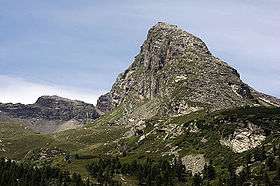 View from San Bernardino (east side) | |
| Highest point | |
| Elevation | 2,967 m (9,734 ft) |
| Prominence | 258 m (846 ft) [1] |
| Parent peak | Rheinwaldhorn |
| Coordinates | 46°27′57.2″N 9°08′14.8″E / 46.465889°N 9.137444°ECoordinates: 46°27′57.2″N 9°08′14.8″E / 46.465889°N 9.137444°E |
| Geography | |
 Piz de Mucia Location in Switzerland | |
| Location | Graubünden, Switzerland |
| Parent range | Lepontine Alps |
Piz de Mucia is a mountain of the Swiss Lepontine Alps, overlooking San Bernardino in the canton of Graubünden. It lies south-east of the Zapporthorn, between the valleys of Calanca and Mesolcina.
References
External links
This article is issued from
Wikipedia.
The text is licensed under Creative Commons - Attribution - Sharealike.
Additional terms may apply for the media files.