Piz Vadret
| Piz Vadret | |
|---|---|
 | |
| Highest point | |
| Elevation | 3,229 m (10,594 ft) |
| Prominence | 659 m (2,162 ft) [1] |
| Isolation | 9.7 km (6.0 mi) [2] |
| Parent peak | Piz Kesch |
| Coordinates | 46°41′13.4″N 9°57′45.5″E / 46.687056°N 9.962639°ECoordinates: 46°41′13.4″N 9°57′45.5″E / 46.687056°N 9.962639°E |
| Geography | |
 Piz Vadret Location in Switzerland | |
| Location | Graubünden, Switzerland |
| Parent range | Albula Alps |
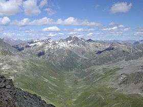
Piz Vadret is a mountain of the Albula Alps, in Graubünden. With an altitude of 3,229 metres above sea level, Piz Vadret is the highest mountain of the Albula Alps north of Piz Kesch. At the base of the north face lies a glacier named Vadret da Grialetsch. The closest locality is Brail, in the Engadin.
References
- ↑ Retrieved from the Swisstopo topographic maps and Google Earth. The key col is the Sella da Ravais-ch at 2,570 metres.
- ↑ Retrieved from Google Earth. The nearest point of higher elevation is east of Piz Kesch.
External links
This article is issued from
Wikipedia.
The text is licensed under Creative Commons - Attribution - Sharealike.
Additional terms may apply for the media files.