Pit 7 Dam
| Pit No. 7 Dam | |
|---|---|
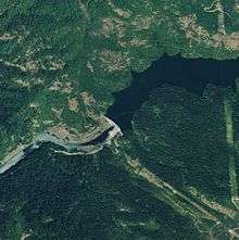 Satellite view | |
| Country | United States |
| Location | Shasta County, California |
| Coordinates | 40°50′53″N 121°59′26″W / 40.84806°N 121.99056°WCoordinates: 40°50′53″N 121°59′26″W / 40.84806°N 121.99056°W |
| Opening date | 1965 |
| Owner(s) | PG&E |
| Dam and spillways | |
| Type of dam | Concrete arch-gravity |
| Impounds | Pit River |
| Height | 230 ft (70 m) |
| Length | 770 ft (230 m) |
| Spillway capacity | 11,400 cu ft/s (320 m3/s) |
| Reservoir | |
| Total capacity | 34,100 acre⋅ft (42,100,000 m3) |
| Catchment area | 5,170 sq mi (13,400 km2) |
| Surface area | 470 acres (190 ha) |
| Power Station | |
| Installed capacity | 110 MW (150,000 hp) |
| Annual generation | 478,390,000 KWh (2001–2012)[1] |
Pit 7 Dam is a run-of-the-river hydroelectric dam across the Pit River in northern California. Located just upstream of Shasta Lake, it is a concrete arch-gravity structure and its powerhouse has a capacity of 110 megawatts (150,000 hp). The dam is owned by the Pacific Gas and Electric Company.[2]
See also
References
- ↑ "California Hydroelectric Statistics & Data". California Energy Commission. Retrieved 2018-04-27.
- ↑ "Project Summary - McCloud-Pit". Energy NewsData. Retrieved 2011-10-22.
This article is issued from
Wikipedia.
The text is licensed under Creative Commons - Attribution - Sharealike.
Additional terms may apply for the media files.