Piracicaba River
| Piracicaba River | |
|---|---|
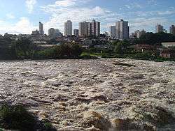 Piracicaba River crossing the city of Piracicaba | |
| Country | Brazil |
| Physical characteristics | |
| Main source | São Paulo state |
| River mouth | Tietê River |
| Length | 115 km (71 mi) |
| Discharge |
|
| Basin features | |
| Basin size | 12,400 km2 (4,800 sq mi) |
The Piracicaba River is a river of São Paulo state in southeastern Brazil. It is a tributary of the Tietê River, which it joins in the reservoir created by Barra Bonita Dam. There is also another Piracicaba river in the state of Minas Gerais, named after the one from São Paulo state, since the early colonizers of Minas Gerais largely came from São Paulo.
Geography
The basin of the Piracicaba River extends over an area of 12,531 km², located in the southeast of the state of São Paulo and extreme south of Minas Gerais.[1]
The Piracicaba river is born from the junction of the Atibaia and Jaguari rivers, in the municipality of Americana. After crossing the city of Piracicaba, it receives the waters of its main tributary, Corumbataí river. The Piracicaba River runs 115 km from its source to its mouth on the Tietê River between the municipalities of Santa Maria da Serra and Barra Bonita.
Piracicaba has several meanders that make the waters of its bed suitable for the navigation of small boats after the city of Piracicaba. Among the versions of the origin of the river name, there is that, due to its meanders, the fish get impounded, meaning in Tupi "place where the fish stops".[2]
The watershed of the Piracicaba River is located in one of the most developed regions of the state of São Paulo, encompassing municipalities such as Bragança Paulista, Campinas, Limeira, Americana, Atibaia, Rio Claro, Santa Bárbara d'Oeste and Piracicaba.
See also
Coordinates: 22°36′53″S 48°19′12″W / 22.61472°S 48.32000°W[3]
References
- ↑ "Projeto Beira Rio- Plano de Ação Estruturador" (PDF). IPPLAP. Retrieved November 16, 2016.
- ↑ "Full text of "Diccionario geographico da provincia de S. Paulo: precedido de um estudo sobre a estructura da ..."". archive.org. Retrieved 2016-11-16.
- ↑ GNS coordinates adjusted using Google Maps and GeoLocator