Pip Ivan (Chornohora)
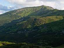
Pip Ivan (Ukrainian: Піп Іван; Polish: Pop Iwan) is the third highest peak[1] (after Hoverla and Brebeneskul) of the Chornohora (Czarnohora) range, with height of 2022 meters (6,634 ft) above sea level.[2]
In the interwar period (1918–1939) the peak marked the Polish - Czechoslovak, from March 1939 Polish - Hungarian border and numerous skirmishes between OUN and Polish border troops took place in the area.
On the peak of Chorna Hora (then in Polish called Pop Iwan), the Polish government built in the years 1936–1938 an impressive construction, an astronomical and meteorogical observatory, which was commonly called "Biały Słoń" ("White Elephant"). Today, the construction is in ruins.
Now the Chornohora range, is located in Ukraine.
References
- ↑ Ukrayinska Pravda. 7 October 2015 Відновлення покинутої обсерваторії на вершині Карпат триває. ФОТО (Renovation of the abandoned observatory at the Carpathian peak continues).
- ↑ Ukraine: The Bradt Travel Guide Andrew Evans - 2007 - 1841621811 Page 247 The mountain town is a good point from which to hike the lower Chornohora (Pip Ivan and Smotrych) and to head off on some long and rewarding walks across the most idyllic region of the Carpathian countryside. Although not inside the boundaries of the national park, Verkhovyna is the transfer point between buses and taxis to and from Yaremche and Ivano-Frankivsk with Kosiv and Kolomiya. Eight buses go to and from Yaremche every day as well as Kosiv (1 hour).
Coordinates: 48°02′49″N 24°37′38″E / 48.04694°N 24.62722°E