Pinnacle Glacier (Mount Adams)
| Pinnacle Glacier | |
|---|---|
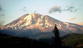 Pinnacle Glacier on the far left of the photo, starting at around halfway up the rocky portion of the mountain. | |
 Pinnacle Glacier | |
| Type | Mountain glacier |
| Coordinates | 46°12′25″N 121°31′43″W / 46.20694°N 121.52861°WCoordinates: 46°12′25″N 121°31′43″W / 46.20694°N 121.52861°W[1] |
| Area | 1.41 km2 (0.54 sq mi) in 2006[2] |
| Length | 1.2 mi (1.9 km) |
| Terminus | Talus |
| Status | Retreating |
Pinnacle Glacier is located on the west slopes of Mount Adams a stratovolcano in Gifford Pinchot National Forest in the U.S. state of Washington.[3] The glacier descends from approximately 10,000 ft (3,000 m) to a terminus near 7,200 ft (2,200 m).[3] Pinnacle Glacier lost 7 percent of its surface area between 1904 and 2006.[2]
See also
References
- ↑ "Pinnacle Glacier". Geographic Names Information System. United States Geological Survey. Retrieved 2012-11-11.
- 1 2 Sitts, Danielle; Andrew G. Fountain; Matthew J. Hoffman (2010). "Twentieth Century Glacier Change on Mount Adams, Washington, USA" (pdf). Northwest Science. Northwest Scientific Association. 84 (4): 378–385. doi:10.3955/046.084.0407. Retrieved 2012-11-11.
- 1 2 Mount Adams West, WA (Map). TopoQwest (United States Geological Survey Maps). Retrieved 2012-11-11.
This article is issued from
Wikipedia.
The text is licensed under Creative Commons - Attribution - Sharealike.
Additional terms may apply for the media files.