Pingfeng Mountain
Coordinates: 24°09′05.7″N 121°20′27.0″E / 24.151583°N 121.340833°E
| Pingfeng Mountain | |
|---|---|
|
屏風山 | |
 | |
| Highest point | |
| Elevation | 3,250 m (10,660 ft) |
| Listing | Mountains in Taiwan |
| Geography | |
| Location | Xiulin, Hualien County, Taiwan |
| Parent range | Central Mountain |
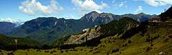
The Pingfeng Mountain (Chinese: 屏風山; pinyin: Píngfēng Shān) is a mountain in Xiulin Township, Hualien County, Taiwan. It is the 98th tallest peak in Taiwan with its main peak reaches a height of 3,250 m.[1][2]
Geology
The mountain is located within the Central Mountain Range.
See also
References
- ↑ "Taroko National Park > Regulations > Fees & Permits > Q & A". taroko.gov.tw. Retrieved 2014-08-23.
- ↑ "Hualien Tourist Service Network". hl.gov.tw.
This article is issued from
Wikipedia.
The text is licensed under Creative Commons - Attribution - Sharealike.
Additional terms may apply for the media files.