Pinet (power station)
| Pinet | |
|---|---|
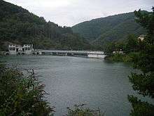 Pinet barrage on the Tarn. | |
| Country | France |
| Location | St Victor et Melvieu, Aveyron |
| Coordinates | 44°04′13″N 2°48′17″E / 44.0702°N 2.8046°ECoordinates: 44°04′13″N 2°48′17″E / 44.0702°N 2.8046°E |
| Purpose | Hydroelectric |
| Construction began | 1929 |
| Opening date | 1932 (restored 1988-90) |
| Dam and spillways | |
| Height | 41 m (135 ft) |
| Length | 175 m (574 ft) |
| Reservoir | |
| Total capacity | 4.4 million m³ |
| Surface area | 1.09 km2 (0.42 sq mi) |
| Normal elevation | 320 m (1,050 ft) |
| Power Station | |
| Operator(s) | EDF |
| Type | Run-of-the-river |
| Hydraulic head | 36.4 m (119 ft) |
| Turbines | 5 x Francis turbine |
| Installed capacity | 42.5 MW (57,000 hp) |
| Annual generation | 104 GWh (370 TJ) |
Pinet is a barrage and hydroelectric power station on the River Tarn in Saint-Victor-et-Melvieu in Aveyron, southern France.
The barrage was built in 1932, and the station has five Francis turbines generating 42.5MW. The dam is 175 metres (574 ft) long and 41 metres (135 ft) high.[1]
Description
The dam
The dam constructed in 1929 was regulated by 18 groups of vannes secteur (sluices). These were replaced by 3 vannes-clapet (rising barriers), 6.2 by 40 metres (20 ft × 131 ft) in dimension. These gave the dam capacity to cope with crues (floods) of up to 4 400 m3/s.[2]
The lake
The barrage raises the level of the Tarn by 40 m and the lake formed, the Lac de Pinet, is at an altitude of 320 m and has a surface area is 1.09 km². It lies in the communes of Saint-Rome-de-Tarn, Viala-du-Tarn and Saint-Victor-et-Melvieu.
The turbine hall
The turbine hall is 500 metres (1,600 ft) downstream from the barrage, it contains five Francis turbines which generate 42.5 megawatts (57,000 hp).[3]
See also
References
- ↑ Hydrelect info: Pinet in French, accessed 2012-09-27
- ↑
- ↑ Hydroweb: Pinet Archived 2012-02-16 at the Wayback Machine. in French, accessed 2012-09-27
External links
| Wikimedia Commons has media related to Tarn River. |
- Hydroweb Pouget in French