Pieterpad
| Pieterpad | |
|---|---|
 Route of the Pieterpad | |
| Length | 498 km (309 mi) |
| Location | Netherlands |
| Trailheads |
Pieterburen, Groningen Maastricht, Limburg |
| Use | Hiking |
| Elevation | |
| Highest point | Schimmert, 135 m (443 ft) |
| Hiking details | |
| Season | All year |
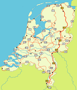
The Pieterpad is a long distance walking route in the Netherlands. The trail runs 498 kilometres (309 mi) from Pieterburen, in the northern part of Groningen, south through the eastern part of the Netherlands to end just south of Maastricht, on the top of Mount Saint Peter (St Pietersberg), at a height of 109 metres (358 ft). The Pieterpad is one of the official Long Distance Paths in the Netherlands (Lange Afstand Wandelpad Nummer 9) and by far the most popular of its long distance walking routes. It is possible to walk the route in either direction, and throughout the year. It is well signposted, and is well served by public transport and accommodation throughout its length. The official guide book is in two volumes, Pieterburen-Vorden and Vorden-Maastricht.[1] A dedicated website (in Dutch) also gives updated accommodation details.[2] Although the walking is always easy and never remote, it is a varied and often beautiful walk, passing through woods, polders, heathland, and numerous small Dutch villages.
History
The trail was the idea of Toos Goorhuis-Tjalsma living in Tilburg, in the south of the Netherlands and her friend Bertje Jens living in Groningen in the north of the Netherlands. They came up with the idea to design a rambling route between their hometowns, later re-organised between the far north to the far south. The route has been officially open since 1983.
Stages
The route of the Pieterpad is described in the following stages:
| 1 | Pieterburen | Winsum | 12 km |
| 2 | Winsum | Groningen | 19 km |
| 3 | Groningen | Zuidlaren | 21 km |
| 4 | Zuidlaren | Rolde | 18 km |
| 5 | Rolde | Schoonloo | 18 km |
| 6 | Schoonloo | Sleen | 24 km |
| 7 | Sleen | Coevorden | 21 km |
| 8 | Coevorden | Hardenberg | 19 km |
| 9 | Hardenberg | Ommen | 21 km |
| 10 | Ommen | Hellendoorn | 21 km |
| 11 | Hellendoorn | Holten | 16 km |
| 12 | Holten | Laren | 15 km |
| 13 | Laren | Vorden | 13 km |
| 14 | Vorden | Zelhem | 17 km |
| 15 | Zelhem | Braamt | 18 km |
| 16 | Braamt | Millingen aan de Rijn | 24 km |
| 17 | Millingen | Groesbeek | 20 km |
| 18 | Groesbeek | Gennep | 14 km |
| 19 | Gennep | Vierlingsbeek | 19 km |
| 20 | Vierlingsbeek | Swolgen | 22 km |
| 21 | Swolgen | Venlo | 21 km |
| 22 | Venlo | Swalmen | 23 km |
| 23 | Swalmen | Montfort | 21 km |
| 24 | Montfort | Sittard | 24 km |
| 25 | Sittard | Strabeek (Valkenburg) | 22 km |
| 26 | Strabeek | Sint-Pietersberg | 17 km |
The Pieterpad connects to the international trails E9 at its northern end in Pieterburen and the GR5 at its southern end and crosses the E11 in Oldenzaal and the E8 in Nijmegen. It follows the European walking GR5, which is also part of trail E2. The GR5, which runs through the Ardennes to Nice and the French Alps, is one of the most popular international trails for hikers.
Gallery
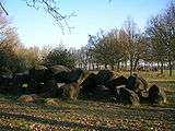 Hunebedden near Rolde
 Hellendoorn to Laren
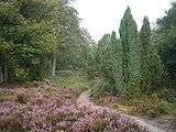 Near Laren
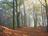 Near Doetinchem
 Groesbeek to Gennep
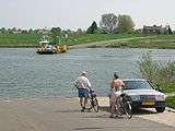 Maas at Grubbenvorst
References
| Wikivoyage has a travel guide for Pieterpad. |
| Wikimedia Commons has media related to Pieterpad. |
- ↑ Pieterpad, Nivon Publishing http://www.nivon.nl (see Wandelen/Gidsen en Kaarten)
- ↑ Pieterpad www site: http://www.pieterpad.nl/