Piding
| Piding | ||
|---|---|---|
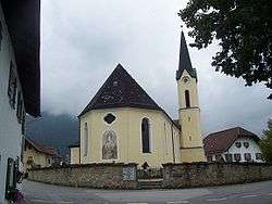 Church of the Birth of the Virgin Mary | ||
| ||
 Piding Location of Piding within Berchtesgadener Land district  | ||
| Coordinates: 47°46′0″N 12°55′0″E / 47.76667°N 12.91667°ECoordinates: 47°46′0″N 12°55′0″E / 47.76667°N 12.91667°E | ||
| Country | Germany | |
| State | Bavaria | |
| Admin. region | Oberbayern | |
| District | Berchtesgadener Land | |
| Government | ||
| • Mayor | Hannes Holzner (CSU) | |
| Area | ||
| • Total | 17.55 km2 (6.78 sq mi) | |
| Elevation | 455 m (1,493 ft) | |
| Population (2017-12-31)[1] | ||
| • Total | 5,451 | |
| • Density | 310/km2 (800/sq mi) | |
| Time zone | CET/CEST (UTC+1/+2) | |
| Postal codes | 83448–83451 | |
| Dialling codes | 08651 | |
| Vehicle registration | BGL | |
| Website | www.piding.de | |

Piding is an approved climatic spa in Bavaria near to the border of Austria close to Bad Reichenhall and Freilassing.
Geography
Geographical position
Piding is located in the middle of the Landkreis Berchtesgadener Land.
The municipal area corresponds to a natural expanse: It is bounded by the mountains Hochstaufen (1771 m) and Fuderheuberg (1.350 m) in the South, by the river Saalach in the East and by the hill Högl in the North-West. In the North-East the Saalach shapes the borderline to Salzburg (Austria).
Districts and Neighbours
The districts are Piding, Kleinhögl, Bichlbruck, Urwies, Mauthausen, Staufenbrücke and Pidingerau.
Immediate neighbours are the town Bad Reichenhall and the municipalities Ainring and Anger.
History
Archaeological troves shows, that the region was already populated in the New Stone Age (about 2800 BC). During the construction of the (former) ski-lift at the Fuderheuberg in 1970 copper bars from the Bronze Age were found.
Religions
The Catholic parish Maria Geburt (birth of Mary) is responsible for this churches:
- parish church Maria Geburt (Piding)
- St. Laurentius (Mauthausen)
- St. Johannes at Johannishögl (no regular masses)
Development of population
1790: 635 inhabitants, 1910: 864, 1946: 1.540, 1985: 3.996, 2000: 5.093, 2002: 5.257.
Coat of arms
The municipal coat of arms from 1962 refers to the former relations to arch-monastery and chapter Salzburg (black lion's head) and to the Höglwörth Abbey (cross-over silver keys).
Politics
Municipal council
Elections in 2014
- CSU: 9 seats
- Free voters: 6 seats
- Alliance 90/The Greens: 3 seats
- SPD: 2 seats
Mayor
First (governing) mayor is Hannes Holzner (CSU), second mayor Walter Pfannerstill(FWG) and third mayor Dr. Bernhard Zimmer (Grüne).
Culture and sights
Music/Tradition
- Club for the preservation of traditional costumes, "D'Staufenecker"
- Traditional band
Buildings
- Schloss Staufeneck
Sport
- tennis hall, tennis courts
- 50 km hiking trails, 12 km cross-country ski runs (tracked)
- Pidinger Klettersteig (fixed rope route) to the Hochstaufen
- Football ground
Economy and infrastructure
Resident Companies
- Autohaus Bachfrieder (car dealer)
- Behindertenwerkstätte (workshop for handicapped people)
- Milchwerke Berchtesgadener Land (dairy)
- Stahl- und Metallbau Heinz Bender KG (metal constructions)
- Eurimpharm (pharmacy)
Traffic
Next to Piding is the last exit of the motorway A 8 (Munich-Salzburg) in front of the border to Austria. The federal road B 20 (Berchtesgaden-Oberpfalz) is tangent to Piding. Piding has its own railway station at the railway line Freilassing-Berchtesgaden.
Education
- Primary and secondary school
- Rupertusschule (school for handicapped persons)
Characters
Honorary citizens
- Max Wieser: former mayor
Literature
- Max Wieser: Pidinger Heimatbuch, 1250 Jahre Piding - Verlag Plenk, Berchtesgaden 1985
References
- ↑ "Fortschreibung des Bevölkerungsstandes". Bayerisches Landesamt für Statistik und Datenverarbeitung (in German). September 2018.
External links
Towns and municipalities in Berchtesgadener Land | ||
|---|---|---|