Piccolomini (crater)
 LRO image | |
| Coordinates | 29°42′S 32°18′E / 29.7°S 32.3°ECoordinates: 29°42′S 32°18′E / 29.7°S 32.3°E |
|---|---|
| Diameter | 88 km |
| Depth | 4.5 km |
| Colongitude | 328° at sunrise |
| Eponym |
Alessandro Piccolomini |
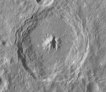
Piccolomini is a prominent lunar impact crater located in the southeastern sector of the Moon. The crater Rothmann lies to the west-southwest, to the north is Fracastorius, to the east-northeast is Weinek, to the east-southeast is Neander, and to the south is Stiborius. The lengthy Rupes Altai begins at the western rim of Piccolomini, curving to the northwest. It is 88 kilometers in diameter and 4,500 meters deep. It is from the Upper Imbrian period, 3.8 to 3.2 billion years ago.[1]
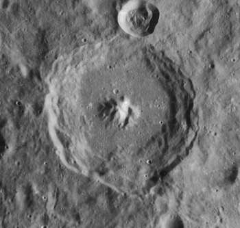
The crater rim has not been severely worn by crater impacts, and the inner wall possesses wide terraces. These structures have been somewhat smoothed by landslips and erosion, most likely induced by seismic activity. An influx of material has entered across the northern rim, flowing down toward the base. The crater floor is relatively smooth, with only minor hills and impact craters. In the middle is a complex central peak surrounded by lesser mounts. The main peak rises to a height of 2.0 kilometers above the surrounding floor.[2][3]
Names
The crater is named after 16th century Italian Archbishop and astronomer Alessandro Piccolomini.,[1] it was given its name by Michael van Langren in 1645, it was later accepted by Giovanni Riccioli, whose 1651 nomenclature system has become standardized.[4][5] One lunar cartographer Johannes Hevelius gave the feature a different name and calls it "Moschus Mons" of the ancient world and grouped it with Fracastorius.[6][7]
Satellite craters
By convention these features are identified on lunar maps by placing the letter on the side of the crater midpoint that is closest to Piccolomini.[8]
| Piccolomini | Latitude | Longitude | Diameter |
|---|---|---|---|
| A | 26.4° S | 30.4° E | 16 km |
| B | 25.8° S | 30.5° E | 12 km |
| C | 27.6° S | 31.1° E | 26 km |
| D | 26.9° S | 32.2° E | 17 km |
| E | 26.1° S | 31.8° E | 18 km |
| F | 26.3° S | 31.8° E | 72 km |
| G | 27.2° S | 34.7° E | 18 km |
| H | 27.9° S | 27.6° E | 9 km |
| J | 25.0° S | 30.1° E | 28 km |
| K | 25.7° S | 29.7° E | 8 km |
| L | 26.1° S | 33.7° E | 12 km |
| M | 27.8° S | 31.8° E | 23 km |
| N | 27.3° S | 26.2° E | 9 km |
| O | 26.6° S | 30.5° E | 11 km |
| P | 30.4° S | 35.9° E | 12 km |
| Q | 30.8° S | 36.4° E | 14 km |
| R | 29.3° S | 35.3° E | 16 km |
| S | 31.6° S | 34.1° E | 21 km |
| T | 28.5° S | 29.0° E | 8 km |
| W | 26.8° S | 29.2° E | 6 km |
| X | 26.9° S | 31.5° E | 8 km |
References
- 1 2 Autostar Suite Astronomer Edition. CD-ROM. Meade, April 2006.
- ↑ Rükl, Antonín (1990). Atlas of the Moon. Kalmbach Books. ISBN 0-913135-17-8.
- ↑ Moore, Patrick (2001). On the Moon. Sterling Publishing Co.. ISBN 0-304-35469-4.
- ↑ Ewen A. Whitaker, Mapping and Naming the Moon (Cambridge University Press, 1999), p.61.
- ↑ Riccioli map of the Moon (1651)
- ↑ Ewen A. Whitaker, Mapping and Naming the Moon (Cambridge University Press, 1999).
- ↑ Hevelius map of the Moon (1647)
- ↑ Bussey, B.; Spudis, P. (2004). The Clementine Atlas of the Moon. New York: Cambridge University Press. ISBN 0-521-81528-2.
| Wikimedia Commons has media related to Piccolomini (crater). |