Picacho Stagefield ARNG Heliport
| Picacho ARNG Heliport | |||||||||||||||||||||||
|---|---|---|---|---|---|---|---|---|---|---|---|---|---|---|---|---|---|---|---|---|---|---|---|
 | |||||||||||||||||||||||
| Summary | |||||||||||||||||||||||
| Airport type | Private use. Permission required prior to landing | ||||||||||||||||||||||
| Owner | United States Army | ||||||||||||||||||||||
| Operator | Arizona Army National Guard | ||||||||||||||||||||||
| Serves | Tucson, Arizona | ||||||||||||||||||||||
| Location | Picacho, Arizona | ||||||||||||||||||||||
| Built | 1943 | ||||||||||||||||||||||
| Elevation AMSL | 1,669 ft / 509 m | ||||||||||||||||||||||
| Coordinates | 32°39′48″N 111°29′14″W / 32.66333°N 111.48722°WCoordinates: 32°39′48″N 111°29′14″W / 32.66333°N 111.48722°W | ||||||||||||||||||||||
| Map | |||||||||||||||||||||||
 PCA  PCA | |||||||||||||||||||||||
| Helipads | |||||||||||||||||||||||
| |||||||||||||||||||||||
Picacho ARNG Heliport (ICAO: KPCA, FAA LID: PCA), also known as Picacho Stagefield Heliport formally Marana Auxiliary Army Airfield No. 1 (Picacho Field) is an Arizona Army National Guard towered training field 4 miles (3.5 nmi; 6.4 km) southeast of Picacho, Arizona.[1] The Airport is owned and operated by the United States Army. The field serves as a training facility for the Western Army National Guard Aviation Training Site based out of Pinal Airpark.[2][3]
Picacho ARNG Heliport is a towered airfield that does not have Class D Airspace ring around the airport on the Phoenix sectional chart this is due to it being a Heliport. Picacho ARNG Heliport should be considered Class D Airspace and the chart instructs pilots to CTC PCA TWR WITHIN 4 NM BELOW 2500 FT AGL.[4]
Marana Auxiliary Army Airfield No. 1 (aka Picacho Field) was one of five Auxiliary fields that served Marana Army Air Field (now: Pinal Airpark) and is part of many Arizona World War II Army Airfields. Picacho Field first appeared on the Phoenix sectional chart in 1945.[5][6]
Facilities
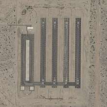
Picacho ARNG Heliport has four asphalt paved runways/helipads:
- Helipad H1 measuring 1,500 ft × 75 ft (457 m × 23 m)
- Helipad H2 measuring 1,500 ft × 75 ft (457 m × 23 m)
- Helipad H3 measuring 1,500 ft × 75 ft (457 m × 23 m)
- Helipad H4 measuring 1,500 ft × 75 ft (457 m × 23 m)[7]
See also
References
- ↑ "AirNav: KPCA - Picacho ARNG Heliport". www.airnav.com. Retrieved 2018-03-18.
- ↑ "WAATS - Western ARNG Aviation Training Site". az.ng.mil. Retrieved 2018-03-18.
- ↑ Pike, John. "Western Army National Guard Aviation Training Site, (WAATS) / Silverbell Army Heliport". Retrieved 2018-03-18.
- ↑ "PCA - Picacho Arng Heliport | SkyVector". skyvector.com. Retrieved 2018-03-24.
- ↑ "Abandoned & Little-Known Airfields: Arizona, Northern Tucson area". www.airfields-freeman.com. Retrieved 2018-03-18.
- ↑ "Airport history". Town of Marana. Retrieved 2018-03-18.
- ↑ "FAA Airport Master Record for PCA". Airport IQ 5010.
External links
- Resources for this airport:
- FAA airport information for PCA
- AirNav airport information for PCA
- FlightAware airport information and live flight tracker
- SkyVector aeronautical chart for PCA