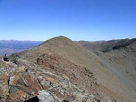
Pic del Segre
| Pic del Segre | |
|---|---|
| Puigmal del Segre | |
 | |
| Highest point | |
| Elevation | 2,843 m (9,327 ft) |
| Listing | Mountains of Catalonia |
| Coordinates | 42°23′49.35″N 2°07′16.7″E / 42.3970417°N 2.121306°ECoordinates: 42°23′49.35″N 2°07′16.7″E / 42.3970417°N 2.121306°E |
| Geography | |
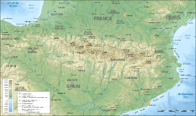 Pic del Segre Location in the eastern Pyrenees | |
| Location |
Queralbs, Ripollès, Catalonia, Spain Llo, Pyrénées-Orientales, France |
| Parent range | Pyrenees |
| Climbing | |
| First ascent | Unknown |
| Easiest route | From Vall de Núria |
Pic del Segre or Puigmal del Segre is a mountain of Catalonia, France and Spain. Located in the Pyrenees, close to Vall de Núria it has an elevation of 2,843 metres (9,327 ft) above sea level.[1] The Segre River has its source by this peak.
See also
References
- ↑ "Topographic maps of Catalonia". Institut Cartogràfic de Catalunya. Retrieved May 22, 2010. .
- Vall de Núria Map, ed. Alpina
External links
This article is issued from
Wikipedia.
The text is licensed under Creative Commons - Attribution - Sharealike.
Additional terms may apply for the media files.