Pic Schrader
| Pic Schrader | |
|---|---|
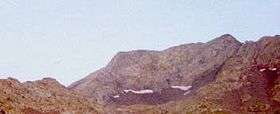 Le Pic Schrader (droite) et la Punta del Sabre (gauche) | |
| Highest point | |
| Elevation | 3,177 m (10,423 ft) |
| Prominence | 639 metres (2,096 ft) |
| Coordinates | 42°41′58″N 0°23′43″E / 42.69944°N 0.39528°ECoordinates: 42°41′58″N 0°23′43″E / 42.69944°N 0.39528°E |
| Geography | |
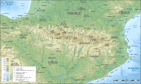 Pic Schrader Location in the Pyrenees | |
| Location | France – Spain |
| Région Communauté |
Midi-Pyrénées Aragon |
| Département Province |
Hautes-Pyrénées Huesca |
| Parent range | Massif du Batchimale (Pyrenees) |
| Climbing | |
| First ascent | August 11, 1878 by Franz Schrader and Henri Passet |
| Easiest route | Par le versant espagnol, en partant de Viados |
The Pic Schrader or Grand Batchimale is a central pyrenean summit, culminating at 3,177 m (10,423 ft), located for the most part in Spain. It buckles the vallée du Louron with its impressive silhouette
It is located between the massifs of Monte Perdido and Posets.
Toponymy
Formerly named Grand Batchimale, it was renamed in honour of mountaineer, cartographer, geographer and landscape painter Franz Schrader (1844-1924), who charted many mountains and valleys in the Pyrenees in the 19th century and who carried out its first known ascension on August 11, 1878 along with mountain guide Henri Passet.
The name Batchimale is the name of the borderline crest of which it is the highest summit (there is also the Petit Batchimale). Franz Schrader quotes in his Mémoires the term Pic Pétard in the sense of Pic Tonnerre « thunder ».[1]
Topography
It is located on the Franco-Spanish borderline crest between the vallée du Louron (Hautes-Pyrénées) and the Spanish Huesca province, which is also situated on the pyrenean watershed.
History
On August 11, 1878 at 10:05,[1] the first ascent was carried out by Franz Schrader, along with guide Henri Passet, and a porter whose name is forgotten.
Access
One can access the pic Schrader from the French side of the mountain through la vallée de La Pez or from le refuge de La Soula. One can also ascend from the Spanish side, which offers two itineraries : one from Viados, following the western crest of la Punta del Sabre and the other, less frequented, passing by les lacs de Batchimale.
See also
References
- 1 2 Franz Schrader (1936). "Pyrénées, Courses et ascensions". Retrieved 23 February 2009.