Philippopolis (Thrace)
| Φιλιππούπολη | |
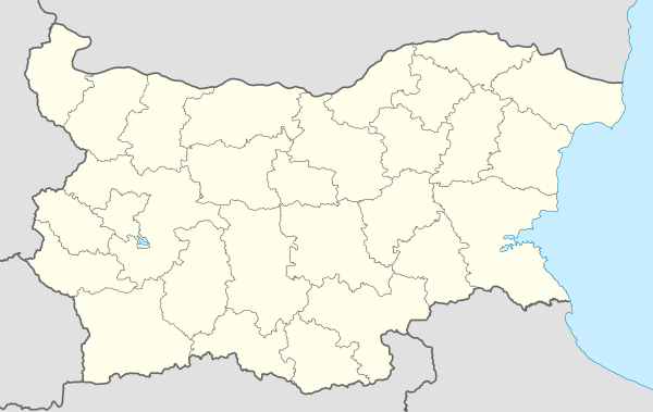 Philippopolis Shown within Bulgaria | |
| Location | Plovdiv, Bulgaria |
|---|---|
| Region | Thrace |
| Coordinates | 42°08′36″N 24°44′56″E / 42.143333°N 24.748889°ECoordinates: 42°08′36″N 24°44′56″E / 42.143333°N 24.748889°E |
| Type | Ancient Thracian, Greek and Roman Settlement |
| Area |
Wall circuit: ca.78 ha (190 acres)[1] Occupied: 78 ha (190 acres)+ |
| History | |
| Founded | 4th century BC |
| Periods | Hellenistic Greece |
| Site notes | |
| Excavation dates | 1960- |
| Website | Site |
| Part of a series on the ancient city of |
| Philippopolis |
|---|
| Buildings and structures |
|
Religious
Fortification
Residential
|
| Related topics |
| • History • Timeline |
Philippopolis is one of the ancient names of the city of Plovdiv (amongst which are Thracian Eumolpia/Pulpudeva, Roman Trimontium) and is the one by which it was known for the most of its recorded history. The city became one of the largest and most important in region, as shown by its still impressive ancient remains, and was called "the largest and most beautiful of all cities" by Lucian.
The city was originally a Thracian settlement, later being invaded by Persians, Greeks, Celts, Romans, Goths, Huns, Bulgarians, Slav-Vikings, Crusaders and Turks.
In 342 BC Philip II of Macedon conquered the Thracian town and gave it his name. Later, Philippopolis became part of the Roman empire and capital of the Roman province Thracia. According to Ammianus Marcellinus, Philippopolis had a population of 100,000 in the Roman period.[2]
History
The earliest signs of habitation on the territory of Philippopolis date as far back as the 6th millennium BC when the first settlements were established.[3][4][5][6][7][8] Archaeologists have discovered fine pottery[9] and objects of everyday life on Nebet Tepe from as early as the Chalcolithic, showing that at the end of the 4th millennium BC, there already was an established settlement there.[10][11][12] Thracian necropolises dating back to the 2nd-3rd millennium BC have been discovered, while the Thracian town Eumolpias was established between the 2nd and the 1st millennium BC.[13]
The town was a fort of the independent local Thracian tribe Bessi.[14] In 516 BC during the rule of Darius the Great, Thrace was included in the Persian empire.[15] In 492 BC the Persian general Mardonius subjected Thrace again, and it became nominally a vassal of Persia until 479 BC and the early rule of Xerxes I.[16] The town was included in the Odrysian kingdom (460 BC-46 AD), a Thracian tribal union. The town was conquered by Philip II of Macedon[17] and the Odrysian king was deposed in 342 BC. Ten years after the Macedonian invasion the Thracian kings started to exercise power again after the Odrysian Seuthes III had re-established their kingdom under Macedonian suzerainty as a result of a somehow successful revolt against Alexander the Great's rule resulting in neither victory, nor defeat, but stalemate.[18] The Odrysian kingdom gradually overcome the Macedonian suzerainty, while the city was destroyed by the Celts as part of the Celtic settlement of Eastern Europe, most likely in the 270s BC.[19] In 183 BC Philip V of Macedon conquered the city, but shortly after the Thracians re-conquered it.
Roman History
In 72 BC the city was seized by the Roman general Marcus Lucullus but was soon restored to Thracian control. In AD 46 the city was finally incorporated into the Roman Empire by emperor Claudius.[20] It gained city status {municipium) in the late 1st century.[21] As Trimontium it was an important crossroad for the Roman Empire and was called "the largest and most beautiful of all cities" by Lucian. Although it was not the capital of the Province of Thrace at this time, the city was the largest and most important centre in the province.[22] It was the seat of the Union of Thracians[23] and the Via Militaris (or Via Diagonalis), the most important military road in the Balkans, passed through the city.[24][25] Roman times were a period of growth and cultural excellence.[26] and the ancient ruins tell a story of a vibrant, growing city with numerous public buildings, shrines, baths, theatres, a stadium. The large scale of public construction during the Flavian Dynasty (69-96 AD) led to the city being named Flavia Philippopolis.
In 172 a second wall was built to encompass the city which had already extended out of the Three Hills into the valley.
It became the provincial capital of Thrace in the early 3rd century.
In about 250 the Battle of Philippopolis involved a long siege by the Goths led by their ruler Cniva and after betrayal by a disgruntled citizen who showed them where to scale the walls,[27] the city was burned[28] and 100,000 of its citizens died or were taken captive[2] according to Ammianus Marcellinus.
It prospered again in the 4th century like many cities in the region.
However, it was destroyed again by Attila's Huns in 441-442 and by the Goths of Teodoric Strabo in 471.[29]
Urban Development
.JPG)
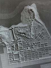
The layout of Philippopolis was revealed to a large extent by archeology between 1965-85 which with historical records confirm the presence of three archeological levels: Hellenistic, Roman and Late Roman.[30]
Hellenistic period
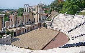
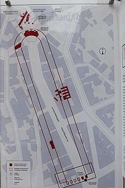
The initial planning and construction of Philippopolis started during Philip II's rule (359–336 BC) and continued during the reign of Alexander the Great and the Diadochi. Some authors assume that the first stage of the construction of Philippopolis ended around 500 BC.[30] The town originally built on the hills was extended to the plain. Archaeologists confirmed that the Hippodamian plan was applied to Philippopolis as in other ancient towns like Miletus, Ephesus, Alexandria and Olynthus.[30][31] Hellenistic Philippopolis had a network of orthogonal gravel streets. Some of the streets had pavements, curbs and proper slopes to accommodate rain water drainage. The intersecting streets formed the rectangular city blocks (insula) with residential and public buildings.[30] A great number of public structures were built in Philippopolis such as theatre, stadium, agora, temples, thermae.
The first city wall of Philippopolis was built as early as the 4th century BC and fragments of this fortification system are visible today on the northern and northwest slopes of Nebet Tepe. The wall was provided with small gates that led to passages or tunnels inside the rock through which steps reached the northern foot of the hill.
Despite the unstable political and economic environment from the 4th century BC to the 1st century BC, large-scale urban planning and complex construction techniques were implemented in Philippopolis. The urban planning model from the Hellenistic period was strictly followed and developed after the city became part of the Roman empire.
Roman period
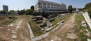
.jpg)

Extensive renovation and large-scale construction took place after 46 AD in order to meet the growing needs of the population. A characteristic of the buildings in Roman Philippopolis was their large scale and lavish decoration which expressed the greatness and influence of the Roman Empire.
The Romans continued the legacy left by the Greek architects of Philippopolis; the unit of measure used by the Romans (the Roman foot - 296 mm) coincided almost entirely with the Attica step used in the Hellenistic period thus allowing them to easily follow the initial urban planning model of the town without making significant alterations.
In the Roman era the built-up area of Philippopolis in the plain totalled 50 ha (120 acres). It included around 150 insulae each with a width of 1 actus (35.5 m) and length of 2 actus (71 m).[30] The existing street network was renovated and expanded with water supply and sewer system beneath it. The area of the road network amounted to 100,000 sq.m.[30] The streets were paved with large granite slabs. The width of a normal street was 15 Roman feet (4.4 m) while the width of the main streets reached 30 Roman feet (8.9 m).[30]
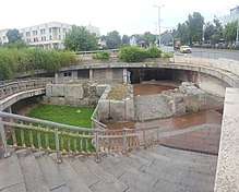
In the 2nd c. AD, the area north of the forum was enhanced and important public buildings from the Hellenistic period like the theatre, the stadium, the agora, treasury and odeon were rebuilt and expanded. In 172 according to an inscription found in the East Gate area form the reign of Emperor Marcus Aurelius, the city walls were strengthened and extended around the city in the plain in the areas to the east and west of the three hills, including, unusually, the stadium. Part of this wall can be seen today under Djumaya Square, next to the Stadium. The odeon was built as a Hellenistic bouleterion, or council chamber, and underwent four reconstructions between the 1st and 4th centuries for use as a small theatre.
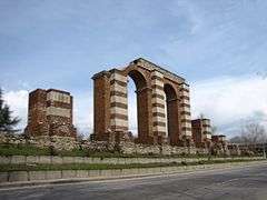
Evidence of the 250/1 destruction by the Goths has been discovered around the Odeon.[32] After the Gothic invasions changes were made particularly noticeable in the East Gate complex, which had a triumphal arch in honour of Hadrian. The gate of the previous period was abandoned and a new route was added to the wall and the archway from the 2nd century was included.
Recent excavations have revealed a 1st c. triumphal arch, only the 2nd in Bulgaria.[33]
Aqueducts
The Roman aqueduct bridge in Plovdiv is the only one standing today in Bulgaria.
Three aqueducts of 22km length supplied mainly the lower part of the city, while the hills relied on wells and rainwater tanks. The aqueducts run parallel to each other in the neighbourhood of the suburb of Komatevo at separation of 30-40m, one a pipeline of clay pipes and two partially overhead aqueducts.[34]
A section of the "western" aqueduct, which is considerably more massive, has been partially restored on Komatevsko Shose. Piers are also visible at the Roman stadium. Recent excavations have revealed more of the piers dating from the 2nd c. AD. [35]
It is assumed that the three aqueducts converged on the western slopes of Djendemtepe into a distribution tank (castellum aquae) which seems to have been destroyed in the construction of the modern tunnel.[36]
The source of the water supply network was three waterfalls on the slopes of the Rhodope Mountains, two in the Marata locality near today's village of Markovo and one in the Kaynitsite locality near the present town of Kuklen. The catchments at Markovo are well researched; one of them is an underground reservoir measuring 13 × 7 m, partially destroyed; the second is a complex tunnel system: a central gallery and side branches. It is not fully investigated, but the length of one of the lateral branches is 76 m.
The distribution network in the city itself is located under the streets, with pipelines along all north-south streets, but only under a few in east-west directions. Street pipelines are built with clay pipes, with branches to separate houses and fountains with lead. The pipelines led to many public fountains and fountains which, although not found, are known from many sculptural fragments.
The total water flow is estimated at around 43,000 cubic metres per day.
References
- ↑ Марк Аврелий и Филипопол
- 1 2 Елена Кесякова; Александър Пижев; Стефан Шивачев; Недялка Петрова (1999). Книга за Пловдив (in Bulgarian). Пловдив: Издателство "Полиграф". pp. 47–48. ISBN 954-9529-27-4.
- ↑ "Archaeologists Explore Ancient Roman Forum of Philippopolis". Popular Archaeology. 14 April 2014. Retrieved 7 October 2016.
- ↑ "Philippopolis Album", Kesyakova Elena, Raytchev Dimitar, Hermes, Sofia, 2012, ISBN 978-954-26-1117-2
- ↑ History (Plovdiv) Official website in English
- ↑ Райчевски, Георги (2002). Пловдивска енциклопедия. Пловдив: Издателство ИМН. p. 341. ISBN 978-954-491-553-7.
- ↑ Кесякова, Елена; Александър Пижев; Стефан Шивачев; Недялка Петрова (1999). Книга за Пловдив. Пловдив: Издателство "Полиграф". pp. 17–19. ISBN 954-9529-27-4.
- ↑ Darik
- ↑ "Plovdiv: New ventures for Europe's oldest inhabited city" Archived 2011-05-11 at the Wayback Machine.. The Courier. January–February 2010.
- ↑ Детев П., Известия на музейте в Южна България т. 1 (Bulletin des musees de la Bulgarie du sud), 1975г., с.27, ISSN 0204-4072
- ↑ Детев, П. Разкопки на Небет тепе в Пловдив, ГПАМ, 5, 1963, pp. 27–30.
- ↑ Ботушарова, Л. Стратиграфски проучвания на Небет тепе, ГПАМ, 5, 1963, pp. 66–70.
- ↑ Archeological investigation of Plovdiv European Capital of Culture for 2019 (in Bulgarian)
- ↑ Елена Кесякова; Александър Пижев; Стефан Шивачев; Недялка Петрова (1999). Книга за Пловдив (in Bulgarian). Пловдив: Издателство "Полиграф". pp. 20–21. ISBN 954-9529-27-4.
- ↑ The Oxford Classical Dictionary by Simon Hornblower and Antony Spawforth, ISBN 0-19-860641-9," page 1515, "The Thracians were subdued by the Persians by 516"
- ↑ The orders, medals, and history of the Kingdom of Bulgaria by Dimitri Romanoff, p. 9
- ↑ История на България, Том 1, Издателство на БАН, София, 1979, p. 206.
- ↑ Conquest and Empire: The Reign of Alexander the Great by A. B. Bosworth s,"page 12,"Cambridge University Pres"
- ↑ Bulgaria. University of Indiana. 1979. p. 4.
- ↑ Dimitrov, B. (2002). The Bulgarians – the first Europeans (in Bulgarian). Sofia: University press "St Climent of Ohrid". p. 17. ISBN 954-07-1757-4.
- ↑ История на България, Том 1, Издателство на БАН, София, 1979, p. 307.
- ↑ Lenk, B. – RE, 6 A, 1936 col. 454 sq.
- ↑ Римски и ранновизантийски градове в България, p. 183
- ↑ "Cultural Corridors of South East Europe/Diagonal Road". Association for Cultural Tourism.
- ↑ Николов, Д. Нови данни за пътя Филипопол-Ескус, София, 1958, p. 285
- ↑ Dimitrov, B. (2002). The Bulgarians – the first Europeans (in Bulgarian). Sofia: University press "St Climent of Ohrid". pp. 18–19. ISBN 954-07-1757-4.
- ↑ Further Dexippus (2) By Christopher P Jones, https://www.academia.edu/11913736/Further_Dexippus_online_
- ↑ http://archaeologyinbulgaria.com/2018/03/28/archaeologists-find-traces-of-251-ad-invasion-of-roman-empire-by-goths-during-digs-at-antiquity-odeon-in-bulgarias-plovdiv/
- ↑ Roman Plovdiv: History
- 1 2 3 4 5 6 7 "Древният Филипопол", arch. М. Mateev, "Жанет 45", Plovdiv, 1999, ISBN 978-954-491-821-7
- ↑ Trakia, V.Velkov, Plovdiv, 1976
- ↑ http://archaeologyinbulgaria.com/2018/03/28/archaeologists-find-traces-of-251-ad-invasion-of-roman-empire-by-goths-during-digs-at-antiquity-odeon-in-bulgarias-plovdiv/
- ↑ http://archaeologyinbulgaria.com/2018/05/07/archaeologists-find-1st-century-ad-roman-triumphal-arch-from-ancient-philipopolis-in-bulgarias-plovdiv/
- ↑ Ivan Tsvarov: The Aqueducts in the Bulgarian Lands 2-4th c. AD. ISBN 978-619-168-190-7
- ↑ http://archaeologyinbulgaria.com/2017/01/12/earliest-roman-aqueduct-of-ancient-philipopolis-discovered-in-bulgarias-plovdiv/
- ↑ Kesiakova, Elena and others. Book about Plovdiv. Plovdiv, Publishing House "Poligraph", 1999. ISBN 954-9529-27-4 .