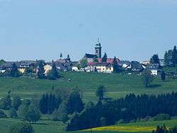
Pfarrkirchen im Mühlkreis
| Pfarrkirchen im Mühlkreis | ||
|---|---|---|
 | ||
| ||
 Pfarrkirchen im Mühlkreis Location within Austria
Location in the district
| ||
| Coordinates: 48°30′16″N 13°49′32″E / 48.50444°N 13.82556°ECoordinates: 48°30′16″N 13°49′32″E / 48.50444°N 13.82556°E | ||
| Country | Austria | |
| State | Upper Austria | |
| District | Rohrbach | |
| Government | ||
| • Mayor | Hermann Gierlinger (ÖVP) | |
| Area | ||
| • Total | 31 km2 (12 sq mi) | |
| Elevation | 819 m (2,687 ft) | |
| Population (14 June 2016)[1] | ||
| • Total | 1,488 | |
| • Density | 48/km2 (120/sq mi) | |
| Time zone | UTC+1 (CET) | |
| • Summer (DST) | UTC+2 (CEST) | |
| Postal code | 4141 | |
| Area code | 07285 | |
| Vehicle registration | RO | |
| Website | www.pfarrkirchen.at | |

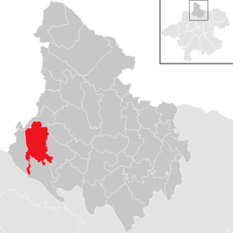
Pfarrkirchen im Mühlkreis is a municipality in the district of Rohrbach in the Austrian state of Upper Austria.
Population
| Historical population | ||
|---|---|---|
| Year | Pop. | ±% |
| 1869 | 1,754 | — |
| 1880 | 1,717 | −2.1% |
| 1890 | 1,620 | −5.6% |
| 1900 | 1,485 | −8.3% |
| 1910 | 1,528 | +2.9% |
| 1923 | 1,481 | −3.1% |
| 1934 | 1,485 | +0.3% |
| 1939 | 1,415 | −4.7% |
| 1951 | 1,541 | +8.9% |
| 1961 | 1,462 | −5.1% |
| 1971 | 1,496 | +2.3% |
| 1981 | 1,517 | +1.4% |
| 1991 | 1,512 | −0.3% |
| 2001 | 1,551 | +2.6% |
| 2011 | 1,525 | −1.7% |
| 2017 | 1,479 | −3.0% |
References
- ↑ Statistik Austria - Bevölkerung zu Jahresbeginn 2002-2016 nach Gemeinden, Erstellt am 14.06.2016 (Last accessed 13.12.2016) for Pfarrkirchen im Mühlkreis.
| Wikimedia Commons has media related to Pfarrkirchen im Mühlkreis. |
This article is issued from
Wikipedia.
The text is licensed under Creative Commons - Attribution - Sharealike.
Additional terms may apply for the media files.