''Peter Iredale''
.jpeg)
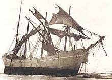
Peter Iredale was a four-masted steel barque sailing vessel that ran ashore October 25, 1906, on the Oregon coast en route to the Columbia River. She was abandoned on Clatsop Spit near Fort Stevens in Warrenton about four miles (6 km) south of the Columbia River channel. Wreckage is still visible, making it a popular tourist attraction as one of the most accessible shipwrecks of the Graveyard of the Pacific.
Namesake
The ship was named after Peter Iredale, who not only owned the vessel as part of his shipping fleet, but was also a well-known figure in Liverpool, England, where his business was headquartered.
The ship was built in Maryport in June 1890, by R. Ritson & Co Ltd for P. Iredale & Porter. She displaced 2,075 tons and measured 87 meters (285 ft) in length and was fashioned from steel plates on an iron frame. She had royal sails above double top and topgallant sails, and was the largest vessel built by Ritson. The ship was originally commanded by Captain G.A. Brown and later by Captain H. Lawrence.
Wreck
Sailing from Salina Cruz, Mexico, on or about September 26, 1906, Peter Iredale was bound for Portland, Oregon with 1,000 tons of ballast and a crew of 27, including two stowaways. The voyage up the coast was unremarkable until the night of 25 October, when Captain H. Lawrence sighted the Tillamook Rock Lighthouse at 3:20 a.m. local time. The crew altered course first east-northeast and then northeast to enter the mouth of the Columbia River in thick mist and a rising tide. Under strong winds out of the west, an attempt was made to wear the ship away from shore, but a heavy northwest squall grounded Peter Iredale on Clatsop Sands (now called Clatsop Spit). High seas and wind drove the ship ashore. A lifeboat was dispatched from Hammond, Oregon and assisted in evacuating the sailors, who were tended to at Fort Stevens. No casualties occurred in the accident.
A Naval Court inquiry was held in Astoria on November 12 and 13, 1906, by the British Vice-Consulate to determine the cause of the wreck. After investigating, no blame was placed on Lawrence and the crew for the loss, and he and his officers were commended for their attempts to save the ship.
There was little damage to the hull and plans were made to tow the ship back to sea, but after several weeks waiting for favorable weather and ocean conditions, the ship had listed to the port (left) and become embedded in the sands. The salvage rights to the ship were sold in 1917, though the wreck was never actually broken up.[1] All that currently remains is the bow, a few ribs, and a couple of masts.[2]
Captain Lawrence's final toast to his ship was: "May God bless you, and may your bones bleach in the sands."[3]
World War II
The Oregon Coast saw live bombardment of the U.S. mainland from Japanese submarines during the World War II when several shells were fired at Fort Stevens on June 20, 1942. Though the wrecked Peter Iredale was in the line of fire, no damage was done to it. The next day, rolls of barbed wire were strung from Point Adams southward to hamper invasion. Peter Iredale was entwined in the wire and remained that way until the end of the war.
Today

Over a century since it ran aground, the remains of Peter Iredale's rusted bow and masts are still visible jutting out of the sand and are a popular tourist attraction.[2] The wreck is contained within Fort Stevens State Park as part of the Lewis and Clark National and State Historical Parks.
See also
- New Carissa (a more recent Oregon Coast shipwreck)
References
- James A. Gibbs (June 1983). Shipwrecks of the Pacific Coast. Binford & Mort Publishing. ISBN 0-8323-0391-7.
- ↑ John, Finn J.D. (August 26, 2012). "Schemers sought to seize Peter Iredale shipwreck, sell for scrap". Offbeat Oregon History. Retrieved January 27, 2017.
- 1 2 "The Peter Iredale". Photograph Oregon. Retrieved January 27, 2017.
- ↑ The Associated Press (October 29, 2009). "100 Years on the Beach". Statesman Journal.
External links
| Wikimedia Commons has media related to Peter Iredale shipwreck. |
- Peter Iredale at iredale.de
- The Maryport sailing ship Peter Iredale
- 1906 port view of wrecked Peter Iredale
- Historic image of the wreck of the Peter Iredale from Salem Public Library
Coordinates: 46°10′42″N 123°58′52″W / 46.178361°N 123.981003°W
| Shipwrecks |
|
|---|---|
| Other incidents |
|
1905 | |