Perušić
| Perušić | |||
|---|---|---|---|
| Town | |||
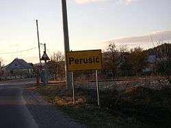 A sign near Perusic. | |||
| |||
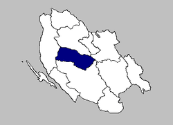 The Municipality of Perušić within Lika-Senj County. | |||
| Coordinates: 44°39′N 15°23′E / 44.650°N 15.383°ECoordinates: 44°39′N 15°23′E / 44.650°N 15.383°E | |||
| Country | Croatia | ||
| County | Lika-Senj County | ||
| Municipality | Perušić | ||
| Perušić | 1487 | ||
| Founded by | Dominic and Gaspar Perušić | ||
| Government | |||
| Area | |||
| • Total | 380.69 sq mi (986.0 km2) | ||
| Population (2011) | |||
| • Total | 2,638 | ||
| • Density | 6.9/sq mi (2.7/km2) | ||
| Time zone | UTC+1 Central European Time | ||


Perušić is a town (gradića) and a municipality (općina) in Lika-Senj County, Croatia. The municipality has 2,638 inhabitants, while the town itself has 852.[1] The municipality is within the mountainous Lika region of central Croatia. The Kosinj region is located near the town.
Perušić is one of the poorest inhabited municipalities in Croatia, with a shrinking population. Farming and agricultural industries are the main occupations. The small settlements of the municipality are built on hillsides due to frequent flooding.
Geography
The Town of Perušić is located in the southeastern part of Lika, at an altitude of 575–600 metres (1,886–1,969 ft), in a valley of the Lika River watershed. It lies in a field, Perušićkog polja, bounded by the hills west of Klis and the railway line east of the Old Town of Perušić (Stari grad Perušića a.k.a. Gradina).
Perušić connects to major roadways including state road D50 (Otočac to Gospić), and the Zagreb–Split highway. The main railway line MP11 also connects to Zagreb and Split, with daily passenger and freight service.

History
The region has been inhabited since the ancient times. Stone Age artifacts have been found on the road to Otočac, while more finds come from the Bronze Age including grave sites from the 8th or 9th century BC. In the woods of Begovača near Kosinje there is a Roman monolith engraved with the verdict of a water dispute between Illyrian tribes.
Perušić became an organized settlement in the 16th century, when it was on the border between the Ottoman Empire and European states. It was first called Perušić in 1487. It was founded by brothers Dominic and Gašpar Perušić, from a noble family who came from the hinterland. The family built a hill fortress, known by various names in writings of that time, including Stari grad Perušića (Old Town of Perušića), Gradina (fortified town), and most often Perušićka kula (Perušić tower).
When the Turks conquered Lika and Krbava, c.1527, the fort became the main stronghold of Turkish Lika. This borderland between three empires – the Habsburg Monarchy including the remains of the Croatian-Hungarian Empire, the Venetian Republic and the Ottoman Empire – was the scene of constant warfare. Liberation from the Turkish authorities in Lika began in 1685.
Until 1918, Perušić (Perussich before 1850) was part of the Austrian monarchy (Kingdom of Croatia-Slavonia after the Compromise of 1867),[2] in the Croatian Military Frontier, administered by the Kommando Ottotschaner Regiment No.2.[3] From the late 19th century to the early 20th century, Perušić was part of the Lika-Krbava County of the Kingdom of Croatia-Slavonia.
After 1945, the forests became general state assets, administered by the District Councils. The Forestry Building in Perušić was erected in 1970.
During the Croatian War of Independence (1991–1995), Perušić was near the front lines. It was not safe even after the stabilization of the battlefield and the international recognition of Croatia as part of the European Community. In addition to artillery attacks, Serbia launched an infantry attack on 19 January 1992 which was repulsed by Croatian troops.[4]
Population
The 18 settlements (naselja) which make up the municipality of Perušić, with their populations,[1] are as follows:
- Bakovac Kosinjski – 126
- Bukovac Perušićki – 91
- Donji Kosinj – 494
- Gornji Kosinj – 132
- Kaluđerovac – 24
- Klenovac – 32
- Konjsko Brdo – 118
- Kosa Janjačka – 98
- Krš – 32
- Kvarte – 193
- Lipovo Polje – 122
- Malo Polje – 74
- Mezinovac – 24
- Mlakva – 51
- Perušić – 852
- Prvan Selo – 97
- Selo Sveti Marko – 34
- Studenci – 44
These settlements tend to be built on hillsides due to flooding of the Perušić field. According to the 2011 census,[1] the municipality was primarily Croat (90.22%) and Serb (8.49%).
The population of the Town of Perušić has fallen by more than a third between 1991 and 2011. Reasons for this include the emigration of population to more developed areas, attacks during the War of Independence, the aging population, and frequent flooding.
Climate
| Climate data for Perušić | |||||||||||||
|---|---|---|---|---|---|---|---|---|---|---|---|---|---|
| Month | Jan | Feb | Mar | Apr | May | Jun | Jul | Aug | Sep | Oct | Nov | Dec | Year |
| Average high °C (°F) | 11 (52) |
11 (52) |
15 (59) |
18 (64) |
24 (75) |
28 (82) |
31 (88) |
31 (88) |
25 (77) |
21 (70) |
15 (59) |
11 (52) |
20.1 (68.2) |
| Daily mean °C (°F) | 6.5 (43.7) |
6 (43) |
9.5 (49.1) |
13 (55) |
18 (64) |
22 (72) |
24.5 (76.1) |
24.5 (76.1) |
19 (66) |
15.5 (59.9) |
10.5 (50.9) |
7 (45) |
15.5 (59.9) |
| Average low °C (°F) | 2 (36) |
1 (34) |
4 (39) |
8 (46) |
12 (54) |
16 (61) |
18 (64) |
18 (64) |
13 (55) |
10 (50) |
6 (43) |
3 (37) |
9.3 (48.7) |
| Average precipitation mm (inches) | 50 (1.97) |
43 (1.69) |
58 (2.28) |
61 (2.4) |
49 (1.93) |
31 (1.22) |
23 (0.91) |
42 (1.65) |
76 (2.99) |
91 (3.58) |
92 (3.62) |
92 (3.62) |
708 (27.87) |
| Average rainy days | 11 | 8 | 9 | 11 | 8 | 7 | 5 | 6 | 9 | 10 | 13 | 13 | 110 |
| Source: World Weather Online[5] | |||||||||||||
The Lika region has a temperate oceanic climate with Köppen climate classification Cfb, moderately humid with a warm summer. The Velebit mountain range restricts the thermal influence of the Adriatic Sea, but allows moist air to reach the interior resulting in high precipitation (particularly in winter and autumn). The growing season is 210–250 days, and there are 140–180 days with temperatures above 10 °C (50 °F).
Economy
Farming and agricultural industries are the main occupation. The nearby highway brought rapid economic development, though Perušić remains one of the poorest inhabited municipalities in Croatia.
Culture
Literature
According to historical documents, Perušić can be called the cradle of Croatian literacy. Shortly after a printing machine was invented in the nearby village of Kosinj, Missale Romanum Glagolitice (Croatian: Misal po zakonu rimskoga dvora) was printed, one of the oldest printed books in Croatia and Europe, with numerous illustrations and ornaments. It was printed in 1483, just 28 years after the Gutenberg Bible.[6]
Sport
The local football team is NK Perušić.
Landmarks
Grabovača
Grabovača is a cave park situated between the Lika karstic plains and fields, 2 kilometres (1.2 mi) from the center of Perušić. It is 770 metres (2,530 ft) above sea level at the mid-elevations of the Velebit mountains, near the karst basin of the river Lika. In an area of 1.5 km2 (0.58 sq mi) there are an abundance of underground karst forms, complex calcite formations. The park represents one-quarter of the protected caves in Croatia. The caves are closed to the public in winter.[7]
Kosinj Bridge
Kosinj Bridge is a 70-metre (230 ft) stone bridge crossing the river Lika, connecting Upper and Lower Kosinj. It was designed in the 19th century by architect Milivoj Frković, built using an early Croatian bridge-building technique known as uklinjenjem kamena (clipping stone).
Kruščica
Lake Krušćica is an artificial lake and reservoir created in 1966 to help control flooding of the Lika. Behind a dam 80 metres (260 ft) high, the reservoir contains a flooded village with the church of St. Ilya.
References
- 1 2 3 "Population by Age and Sex, by Settlements, 2011 Census: Perušić". Census of Population, Households and Dwellings 2011. Zagreb: Croatian Bureau of Statistics. December 2012.
- ↑ Die Poststempel auf der Freimarken-Ausgabe 1867 von Österreich und Ungarn, Edwin Mueller, 1930
- ↑ Map in the Corinphila-Auktionen 2003.
- ↑ "Hrvatski memorijalno-dokumentacijski centar Domovinskog rata". centardomovinskograta.hr. Retrieved 13 July 2015.
- ↑ "Perusic Benkovacki Climate Data". World Weather Online. Retrieved 2012-03-16.
- ↑ https://web.archive.org/web/20070622101423/http://demo.ctk-rijeka.hr/Kosinj/Povijest.htm. Archived from the original on 22 June 2007. Retrieved 24 August 2015. Missing or empty
|title=(help) - ↑ "Pećinski park Grabovača - Pećinski park Grabovača pruža priliku posjetiteljima da se vrate u prošlost, tisućama godina unatrag". pp-grabovaca.hr. Retrieved 13 July 2015.
External links
- Official website (in Croatian)
Subdivisions of Lika-Senj County | ||
|---|---|---|
| Towns |  | |
| Municipalities | ||
| Authority control |
|---|