Perinjanam
Perinjanam
| Perinjanam Perinnanam, Peringanam | |
|---|---|
| village | |
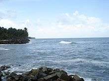
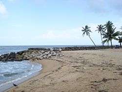 Perinjanam beach | |
| Coordinates: 10°18′50″N 76°8′55″E / 10.31389°N 76.14861°ECoordinates: 10°18′50″N 76°8′55″E / 10.31389°N 76.14861°E | |
| Country |
|
| State | Kerala |
| District | Thrissur |
| Population (2001) | |
| • Total | 20,340 |
| Languages | |
| • Official | Malayalam, English |
| Time zone | UTC+5:30 (IST) |
| PIN | 680686 |
| Telephone code | 0480 |
| Vehicle registration | KL-47 |
| Nearest city | irinjalakuda and kodungallur |
| Sex ratio | 9375:10965 M:F ♂/♀ |
| Lok Sabha constituency | Chalakudy |
| Vidhan Sabha constituency | Kaipamangalam |
| Climate | Coastal climate (Köppen) |
| Website | www.perinjanam.com |
Perinjanam is a village in Thrissur district in the state of Kerala, India.[1] It is one of the smallest villages in Kerala. The coastal village is just half a kilometer wide. National Highway 66 passes through Perinjanam. The neighbouring villages are Mathilakam, Padiyoor and Kaipamangalam. It is bordered by Canoli canal in the east and Arabian Ocean in the west.
Etymology
The name of the village is believed to be originated from the Tamil word Periya Njanamullavarude Nadu (People with good knowledge). However, there is no historical evidence to prove this claim. Perinjanam is just 12 km from Kodungallur and 13 km from Triprayar.
Demographics
As of 2001 India census, Perinjanam had a population of 20340 with 9375 males and 10965 females.[1]
References
- 1 2 Registrar General & Census Commissioner, India. "Census of India : Villages with population 5000 & above". Retrieved 2008-12-10.
External links
This article is issued from
Wikipedia.
The text is licensed under Creative Commons - Attribution - Sharealike.
Additional terms may apply for the media files.