Percy Burn Viaduct
| Percy Burn Viaduct | |
|---|---|
 | |
| Coordinates | 46°14′28″S 167°18′14″E / 46.241086°S 167.303951°ECoordinates: 46°14′28″S 167°18′14″E / 46.241086°S 167.303951°E |
| Carries | Pedestrians on the Hump Ridge Track |
| Crosses | Percy Burn |
| Locale | Fiordland, New Zealand |
| Characteristics | |
| Design | Trestle |
| Material | Timber |
| Total length | 125 metres (410 ft) |
| Height | 36 metres (118 ft) |
| History | |
| Opened | 1923 |
| Closed | 1928 |
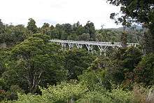
Percy Burn Viaduct is located in the far south of the South Island of New Zealand. It is reputedly the largest surviving wooden viaduct in the world. A former logging tramway, it is now a closed footbridge and the most popular feature of the Tuatapere Hump Ridge Track.
During the early years of the twentieth century, logging companies exploited much of the native timber of New Zealand. The Marlborough Timber Company, one of the country's largest forestry companies, was looking for new areas of forest to mill, and managed to secure the logging rights to an inhospitable and difficult to access area of timber close to Te Waewae Bay in the island's southwestern corner. The main timber milled was rimu.[1]
Access was originally only available by ship, and a wharf and settlement were built at Port Craig, but 25 kilometres of bush tramway were still needed to transport logs to the wharf. These had to cross four large, deep burns, and four large wood-trestle viaducts were built to accomplish this. The largest of these crossed the Percy Burn. Built in 1923, it was 125 metres in length and 36 metres high.
Unfortunately for the company, the timber was not of high quality and proved costly to log. Coupled with falling timber prices (due to the improvement of access between the South Island's cities and the heavily forested West Coast with the completion of the Otira Tunnel), the Port Craig operation was quickly in trouble and was abandoned in 1928, just as maximum timber production had been achieved.[2]
Restoration of the viaduct took place during the 1990s, as part of work on the new Hump Ridge walking track.
Closure
The viaduct, which formed part of the Hump Ridge Track and South Coast Track, was closed to public access in May 2013 due to rotting timber and other safety concerns.[3] An alternate route bypassing the viaduct was constructed by the Department of Conservation.[4]
Its fate was unknown until February 2014 when the Department of Conservation and Environment Southland pledged NZ$480,000 to restore it and the other three viaducts on the former logging rail line.[3][5] As of April 2014 the bridge was closed and restoration work had not begun. Reopening is expected in 2018.[6]
References
- ↑ "SOUTHERN BYWAYS (Evening Star, 1931-10-10)". paperspast.natlib.govt.nz. Retrieved 2018-06-23.
- ↑ "Chapter 37 — Port Craig — Venture and Adventure". nzetc.victoria.ac.nz. Retrieved 2018-06-23.
- 1 2 "Waitutu viaducts to be restored". Radio New Zealand News. 22 February 2014. Retrieved 26 April 2014.
- ↑ Ratley, Neil (20 December 2013). "Community rallies to save historic viaducts". Southland Times. Retrieved 26 April 2014.
- ↑ http://www.doc.govt.nz/about-doc/news/media-releases/2014/historic-southland-viaducts-saved-in-funding-deal/
- ↑ "Standing tall, after all, the giddying Percy Burn viaduct is to reopen". Stuff. Retrieved 2018-06-23.
External links
- New Zealand Department of Conservation Hump Ridge page
- Tuatapere Information Centre
- "History of New Zealand in 100 Places list: Percy Burn Viaduct (1925)". NZHistory. Ministry for Culture and Heritage. Retrieved January 21, 2018.
- 1 to 50,000 map