Penycloddiau
| Penycloddiau | |
|---|---|
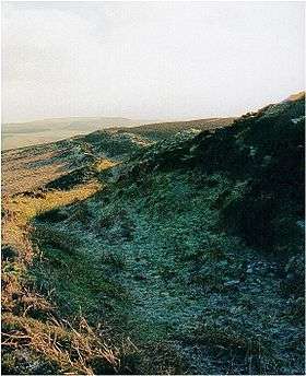 A view of the outer defence wall at Penycloddiau hill fort | |
| Highest point | |
| Elevation | 440 m (1,440 ft) [1] |
| Prominence | 156 m (512 ft) |
| Parent peak | Moel Famau |
| Listing | Marilyn |
| Naming | |
| Translation | hill of the trenches (Welsh) |
| Pronunciation | Welsh: [pɛnəˈklɔðjai] |
| Geography | |
| Location | Flintshire, Wales |
| Parent range | Clwydian Range |
| OS grid | SJ127678 [1] |
| Topo map | OS Landranger 116[1] |
Penycloddiau is a hill in Flintshire, Wales, and one of five Marilyns in the Clwydian Range.
The hill, like Foel Fenlli and Moel Arthur to the south, has an Iron Age hillfort at its summit.[2] It covers 26 hectares (64 acres) making it one of the largest hillforts in Wales.[2] In 2017, excavations by the Clywdian Range Archaeology Group (CRAG) unearthed a significant number of 4,000-year-old stone tools from the Bronze Age, the discovery indicates human activity occurred much earlier than first thought in the area.[3]
Penycloddiau is crossed by the Offa's Dyke Path and the Clwydian Way, two long distance footpaths that traverse the hills in this area.
See also
References
- 1 2 3 Alan Dawson (1992). Relative Hills of Britain. Cicerone Series. Cicerone Press Limited. p. 125. ISBN 978-1-85284-068-6.
- 1 2 John Davies; Nigel Jenkins; Menna Baines, eds. (2008). The Welsh Academy encyclopaedia of Wales. University of Wales Press. pp. 151, 981. ISBN 978-0-7083-1953-6.
- ↑ "Bronze Age tools unearthed in Clwydian range hillforts dig". BBC NEWS. 7 September 2017.
Further reading
- Ian Brown; Mick Sharp & Jean Williamson (2004). "Penycloddiau Iron Age hillfort". Discovering a Welsh landscape: archaeology in the Clwydian range. Landscapes of Britain. 4. Windgather. pp. 75&ndash, 76.
- "Penycloddiau Hillfort". Heather & Hillforts.
- "Penycloddiau Hillfort — Dig In Deeper". Heather & Hillforts.
- "Soldier's Stone, Penycloddiau hillfort". A History of the World. BBC.
- Christopher John Wright (1975). "Moel Arthur and Penycloddiau". A guide to Offa's Dyke path. Constable. pp. 321&ndash, 323. ISBN 978-0-09-460330-1.
External links
| Wikimedia Commons has media related to Penycloddiau Hillfort. |
This article is issued from
Wikipedia.
The text is licensed under Creative Commons - Attribution - Sharealike.
Additional terms may apply for the media files.