Pennsylvania Route 928
| ||||
|---|---|---|---|---|
 | ||||
| Route information | ||||
| Maintained by PennDOT | ||||
| Length | 11.42 mi[1] (18.38 km) | |||
| Existed | 1928 – present | |||
| Major junctions | ||||
| South end | Tollgate Ridge Road at Maryland state line in Thompson Township | |||
| North end |
| |||
| Location | ||||
| Counties | Fulton | |||
| Highway system | ||||
| ||||

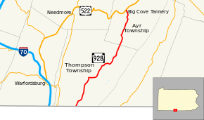
Pennsylvania Route 928 (PA 928) is a 11.42-mile-long (18.38 km) state highway located in Fulton County, Pennsylvania. The southern terminus is the Maryland state line in Thompson Township. The northern terminus is at US 522 in Ayr Township.
Route description
PA 928 begins at the Maryland border in Thompson Township, where the road continues south into that state as Tollgate Ridge Road. From the state line, the route heads northeast on two-lane undivided Tollgate Ridge Road, running through agricultural areas with sparse homes. PA 928 turns east onto Big Cove Tannery Road, making a curve to the northeast. The road continues through more farmland with some woods and residences, crossing the Licking Creek and passing through the community of Dickeys Mountain. Farther northeast, the route heads into more forested areas, running along the western base of Dickeys Mountain. PA 928 crosses into Ayr Township and continues through more woodland with some farm fields and residences, passing through Potts Mills. Farther north, the route crosses Cove Creek and passes through Big Cove Tannery before reaching its northern terminus at US 522.[2][3]
Major intersections
The entire route is in Fulton County.
| Location | mi[1] | km | Destinations | Notes | |
|---|---|---|---|---|---|
| Thompson Township | 0.00 | 0.00 | Tollgate Ridge Road south | Maryland border | |
| Ayr Township | 11.42 | 18.38 | |||
| 1.000 mi = 1.609 km; 1.000 km = 0.621 mi | |||||
See also


References
Route map:
- 1 2 Pennsylvania State Roads - 2010. Harrisburg, Pennsylvania: Pennsylvania Department of Transportation. 2010.
- ↑ Google (May 26, 2011). "overview of Pennsylvania Route 928" (Map). Google Maps. Google. Retrieved May 26, 2011.
- ↑ Fulton County, Pennsylvania Highway Map (PDF) (Map). PennDOT. 2011. Retrieved May 26, 2011.