Pennsylvania Route 580
| ||||
|---|---|---|---|---|
 | ||||
| Route information | ||||
| Maintained by PennDOT | ||||
| Length | 10.141 mi[1] (16.320 km) | |||
| Existed | May 27, 1935[2] – present | |||
| Major junctions | ||||
| South end |
| |||
|
| ||||
| North end |
| |||
| Location | ||||
| Counties | Indiana | |||
| Highway system | ||||
| ||||

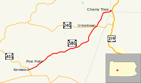
Pennsylvania Route 580 (PA 580) is a 10.1-mile-long (16.3 km) state highway located in Indiana County, Pennsylvania. The southern terminus is at PA 403 in Cherryhill Township. The northern terminus is at US 219 in Cherry Tree.
Route description

PA 580 begins at an intersection with PA 403 in the community of Kenwood in Cherryhill Township, heading east-northeast on a two-lane undivided road. The route passes through agricultural areas with some homes, passing through Manver. The road continues into Green Township and runs through a mix of farmland and woodland with a few residences, serving the community of Pine Flats. Farther northeast, PA 580 heads into more forested areas with some fields and homes, passing through Spruce and curving to the north-northeast. The route crosses PA 240 in Uniontown and continues through more forests. The road turns east and crosses a R.J. Corman Railroad line, heading into Cherry Tree. Here, PA 580 becomes Maple Street and enters residential areas, turning north onto Front Street before turning east onto Cherry Street. The route crosses another R.J. Corman Railroad line and the West Branch Susquehanna River, passing more homes and businesses prior to ending at US 219.[3][4]
Major intersections
The entire route is in Indiana County.
| Location | mi[1] | km | Destinations | Notes | |
|---|---|---|---|---|---|
| Cherryhill Township | 0.000 | 0.000 | |||
| Green Township | 7.779 | 12.519 | |||
| Cherry Tree | 10.141 | 16.320 | |||
| 1.000 mi = 1.609 km; 1.000 km = 0.621 mi | |||||
See also

References
- 1 2 "Pennsylvania state roads". Pennsylvania Spatial Data Access. Pennsylvania Department of Transportation. 2013. Retrieved March 14, 2013.
- ↑ "Make Changes in Route Numbers". The Morning Call. April 18, 1935. p. 2. Retrieved May 2, 2018 – via Newspapers.com.

- ↑ Google (May 29, 2011). "overview of Pennsylvania Route 580" (Map). Google Maps. Google. Retrieved May 29, 2011.
- ↑ Indiana County, Pennsylvania Highway Map (PDF) (Map). PennDOT. 2011. Retrieved May 29, 2011.
External links
| Wikimedia Commons has media related to Pennsylvania Route 580. |
Route map: