Pendoggett
Coordinates: 50°34′54″N 4°47′24″W / 50.58167°N 4.79000°W
Pendoggett
| |
|---|---|
 China Down | |
| Population | 175 |
| OS grid reference | SW997809 |
| Civil parish | |
| Unitary authority | |
| Ceremonial county | |
| Region | |
| Country | England |
| Sovereign state | United Kingdom |
| Post town | ST KEW |
| Postcode district | PL30 |
| Dialling code | 01208 |
| Police | Devon and Cornwall |
| Fire | Cornwall |
| Ambulance | South Western |
| EU Parliament | South West England |
| UK Parliament | |
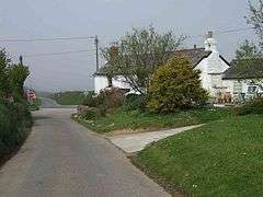
Pendoggett (Cornish: Penndewgos)[1] is a village in the civil parish of St Kew, Cornwall, England, United Kingdom. It is a linear village stradding the B3314 Wadebridge to Delabole road about five miles (8 km) northwest of Wadebridge, four miles (6.5 km) southeast of Delabole, and two miles (3 km) southeast of Port Isaac.[2]
Pendoggett has a population of about 175 people. The name means head of two woods in Cornish; 'Penn' meaning head, 'dew' meaning two and 'goes' being a mutation of 'koes' which means wood. The Cornish Arms is a 16th-century inn.[3]
Pendoggett lies within the Cornwall Area of Outstanding Natural Beauty (AONB). Almost a third of Cornwall has AONB designation, with the same status and protection as a National Park.
References
- ↑ Place-names in the Standard Written Form (SWF) : List of place-names agreed by the MAGA Signage Panel. Cornish Language Partnership.
- ↑ Ordnance Survey: Landranger map sheet 200 Newquay & Bodmin ISBN 978-0-319-22938-5
- ↑ "The Cornish Arms at Pendoggett". Retrieved 2011-10-30.
External links
![]()