Penca Hill
Location of Byers Peninsula on Livingston Island in the South Shetland Islands.

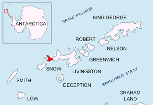
Topographic map of Livingston Island, Greenwich, Robert, Snow and Smith Islands.
Penca Hill is a rocky hill rising to 217 m in Dospey Heights on Byers Peninsula, Livingston Island in the South Shetland Islands, Antarctica.
The feature is descriptively named, the Spanish penca referring to a fleshy leaf or joint of a plant.
Location
Penca Hill is located at 62°36′04.9″S 61°07′23.2″W / 62.601361°S 61.123111°W which is 2.77 km east-southeast of Start Hill, 2.28 km east-southeast of Dulo Hill, 1.93 km southeast of Battenberg Hill, 2.15 km northwest of Varadero Hill and 4.36 km north-northwest of Chester Cone (Chilean mapping in 1971, detailed Spanish mapping in 1992, and Bulgarian mapping in 2009).
Maps
- Península Byers, Isla Livingston. Mapa topográfico a escala 1:25000. Madrid: Servicio Geográfico del Ejército, 1992.
- L.L. Ivanov. Antarctica: Livingston Island and Greenwich, Robert, Snow and Smith Islands. Scale 1:120000 topographic map. Troyan: Manfred Wörner Foundation, 2009. ISBN 978-954-92032-6-4
References
This article is issued from
Wikipedia.
The text is licensed under Creative Commons - Attribution - Sharealike.
Additional terms may apply for the media files.