Pelistry
| Pelistry | |
|---|---|
 Pelistry Pelistry shown within Isles of Scilly | |
| Civil parish |
|
| Unitary authority | |
| Ceremonial county | |
| Region | |
| Country | England |
| Sovereign state | United Kingdom |
| Post town | ISLES OF SCILLY |
| Postcode district | TR21 |
| Dialling code | 01720 |
| Police | Devon and Cornwall |
| Fire | Isles of Scilly |
| Ambulance | South Western |
| EU Parliament | South West England |
| UK Parliament | |
Pelistry (Cornish: Porth Lystry, 'cove for ships') is a small settlement, situated east of Maypole and north of Normandy, in the east of the island of St Mary's in the Isles of Scilly, England.[1] The name is first recorded in 1650 as Porthlistrye.
The main industries are farming and tourism; there is a camp site in Pelistry and nearby is the Carn Vean Tearoom.[2]
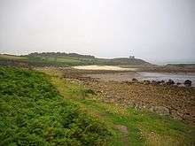
Gilbert's Porth, South Pelistry Bay
The small islet of Toll's Island is situated in Pelistry Bay[3] and can be reached on foot when the tide is low.
References
- ↑ Ordnance Survey mapping
- ↑ Isles of Scilly Holidays Carn Vean Tea Gardens
- ↑ Gilbert's Porth, South Pelistry Bay, St. Mary's; geograph.org
External links
| Inhabited islands |  | |
|---|---|---|
| Uninhabited islands | ||
| Settlements |
| |
| Topics |
| |
This article is issued from
Wikipedia.
The text is licensed under Creative Commons - Attribution - Sharealike.
Additional terms may apply for the media files.