Peldon
| Peldon | |
|---|---|
.jpg) Peldon village sign | |
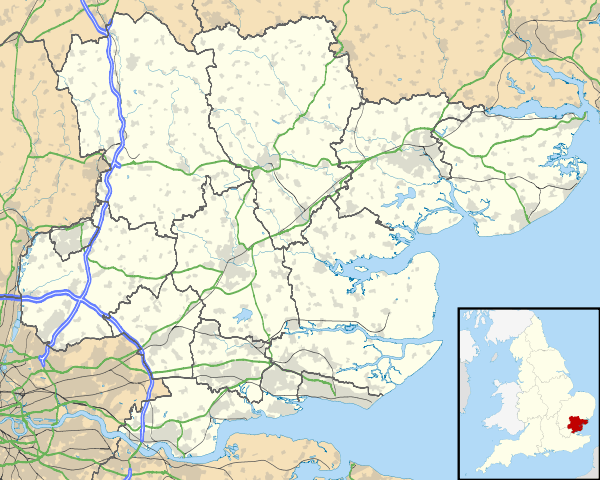 Peldon Peldon shown within Essex | |
| Population | 559 (2011 Census) |
| Civil parish |
|
| District | |
| Shire county | |
| Region | |
| Country | England |
| Sovereign state | United Kingdom |
| Police | Essex |
| Fire | Essex |
| Ambulance | East of England |
| EU Parliament | East of England |

Peldon is a village and civil parish in the Colchester borough of Essex, England and forms part of the Winstred Hundred parish council.[1] Other nearby villages include: Little Wigborough and Langenhoe. The parish church is dedicated to St Mary the Virgin and is a grade I listed building. The population of the parish as of the 2011 census is 559.[2]
In 1870-72 John Marius Wilson's Imperial Gazetteer of England and Wales described Peldon as:
"Peldon, a parish and a sub-district in Lexden district, Essex. The parish lies near Mersea Island, 4½ miles S W of Wivenhoe r. station, and 5½ S by W of Colchester; and has a post-office under Colchester. Acres, 2, 186. Real property, £3, 591. Pop., 501. Houses, 106 The property is much subdivided."[3]
History
During the Iron Age and Roman periods the marshes around Peldon were home to a thriving salt-production industry, and red hills created by this process can be found around the village.[4] Peldon was originally around 2,200 acres of land, equating to approximately 8.9 square kilometres.[5] This land was established by William the Conqueror in 1086 and was later passed on to Sir Thomas Darcy by King Henry VIII. The land was later owned by various local families.[6]
The strongest earthquake to ever strike the UK occurred on the 22nd April 1884. It measured to a 5.1 magnitude on the Richter scale and rendered much of the area around and including Peldon badly damaged. In total, it damaged around 1250 buildings including churches, houses and cottages.[7] It was reported at the time that every single building in Peldon was damaged in some way, including the local church, causing heavy financial ramifications for the local area. The Peldon Rose, the village's 15th century inn, rumoured to have been connected by a smugglers tunnel to nearby Ray Island still exhibits earthquake damage. In 1984 a village festival was held at Kemps Farm, Peldon, to commemorate the 100th anniversary of the earthquake.
Peldon was also affected by World War One. On September the 24th 1916, German Zeppelin L33 was damaged during a bombing attack on London, and later crashed at New Hall Farm, Little Wigborough, only twenty yards from a nearby house.
The occupants of the house, the Lewis family, ran for their lives as the airship hit the ground. The crew ran from the craft and shortly after it exploded. The crew of the aircraft thought that landing in the sea would be far too dangerous, prompting the decision for them to travel further inland.
In the 1870s, Peldon's parish church was described as: "The church stands on an eminence, with commanding view; is later English, with a tower; and was restored in 1859, and then found to include remains of an early Norman church."[8]
Demographics
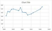

According to the 2011 Census there was a population of 559, with 291 males and 268 females.[11] Of these 559 residents, 282 are residents between the ages of 16 and 74 and are in employment.[12] The main source of employment for the population of Peldon is the repair of motor vehicles and motor cycles, with 47 people working in this area of industry.[13] The age structure of Peldon is primarily made up of people over the age of 45, with around 53% of the residents of Peldon being in this age bracket.[14] Of the 422 residents of Peldon that are aged between 16 and 74, only three people are unemployed. This means that 419 residents in this age bracket are employed and economically active, or are economically inactive due to retirement or long term illness.[15]
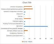
The graph captioned "Occupational structure in 1881" shows the huge difference between male and female jobs. Men worked mainly in agriculture, which dominated the occupational structure as farming was the main occupation in many parishes in Britain at this time. However, a large proportion of women in Peldon had occupational status' of mainly dress making or unknown occupations.
St. Mary's Church
The St. Mary's Church in Peldon generally dates back to the 11th century, with Anglo Saxon origin. The nave originates from the 12th century, the tower the 14th century, and the roof from the 16th century.[16] The church also has a tower that leans in a southwesterly direction, originally thought to have been caused by the 1884 earthquake. However, the leaning tower was reportedly already leaning when the earthquake occurred; it was noted in a book: Mehalah, a Story of the Salt Marshes (1st edition 1880). The leaning tower was actually most likely caused by subsistence due to poor ground.[17]
The church has undergone many changes throughout its existence, having been damaged during the 1884 earthquake and undergoing numerous refurbishments throughout the centuries. These refurbishments and improvements continue to this day, with charity work in Peldon taking place to raise money in order to repair and refurbish the church, a grade 1 listed building. The registered charity The Friends of St. Mary's Peldon raises funds for the church, and has raised over £45,000 thus far.[18]
References
- ↑ http://www.winstred100.org
- ↑ "Parish population 2011". Retrieved 29 September 2015.
- ↑ Wilson, John Marius (1870–72). "Imperial Gazetteer of England and Wales description of Peldon". Vision of Britain. Retrieved 2 May 2017.
- ↑ de Brisay, K.W. (1978) ‘The Excavations of a Red Hill at Peldon, Essex, with notes on some other sites’ Antiquities Journal LVIII pt.1
- ↑ "History of Peldon". Retrieved 29 March 2017.
- ↑ "Ownership of Peldon through time". Retrieved 29 March 2017.
- ↑ "The 1884 Earthquake and its effects on Peldon and the surrounding area". Retrieved 29 March 2017.
- ↑ Wilson, John Marius (1870–72). Imperial Gazetteer of England and Wales.
- ↑ "Population-Peldon".
- ↑ "Peldon-Occupational Structure".
- ↑ "Peldon (Parish): Key Figures for the 2011 Census: Key Statistics". Neighborhood Statistics. Office for National Statistics. Retrieved 2 January 2017.
- ↑ "Industry of the population of Peldon". Retrieved 29 March 2017.
- ↑ "Industry: Wholesale and Retail Trade; Repair of Motor Vehicles and Motor Cycles (Persons)". Retrieved 29 March 2017.
- ↑ "Age structure in Peldon". Retrieved 29 March 2017.
- ↑ "Economic Activity in Peldon census data". Retrieved 29 March 2017.
- ↑ "St. Mary's Church history". Retrieved 29 March 2017.
- ↑ "History of St. Mary's Church and the leaning tower". Retrieved 29 March 2017.
- ↑ "Friends of St. Mary's Peldon Church charity refurbishment work". Retrieved 29 March 2017.