Peachtree Hills
Peachtree Hills is a neighborhood within the Buckhead district of Atlanta, Georgia. It consists primarily of residential buildings (single-family, multi-family, and condos), but restaurants, retail, and mixed use buildings are scattered throughout the neighborhood. Peachtree Battle Shopping Center is located within the borders of Peachtree Hills.
Geography
Peachtree Hills' geographical borders are Peachtree Road on the west, Lindbergh Drive on the north, Amtrak/freight rail lines on the east, and Peachtree Creek on the south. Other neighborhoods that border Peachtree Hills include: Peachtree Battle Alliance, Peachtree Heights West, Peachtree Heights East, Garden Hills, Lindbergh/Morosgo, and Armour.
History

The Civil War Battle of Peachtree Creek took place very close to present day Peachtree Hills.
Peachtree Hills was subdivided from farmland in 1910. It was originally a streetcar suburb of Atlanta in the early 20th century.
Transportation
Peachtree Hills is in close proximity to Peachtree Road, I-85, I-75, SR 400, and the Buford Highway Connector.
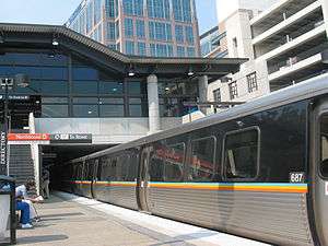
Peachtree Hills is served by the Lindbergh Center MARTA station, which is in walking distance. A proposed Purple Line from Lindbergh Center station to Avondale station would give Peachtree Hills' residents direct access to the CDC and Emory University by MARTA rail.[1]
The Atlanta Beltline northside trail will eventually run near Peachtree Hills, bringing light-rail and easier access to Lindbergh Center station and Armour to the south.
Education
Residents of Peachtree Hills live in the Rivers Elementary, Sutton Middle, and North Atlanta High public school districts.
The following private schools are located near Peachtree Hills:
- Christ the King School (K-8)
- Atlanta International School (PK-12)
- Dar Un-Noor School (PK-8)
- Heritage Preparatory School (PK-8)
- Midtown International School (K-8)
- Atlanta Montessori International School (PK-9)
- Immaculate Heart of Mary Catholic School (K-8)
- Torah Day School of Atlanta (K-8)
- Yeshiva Ohr Yisrael of Atlanta (9-12)
- The Richard and Jean Katz High School for Girls (9-12)
- Ben Franklin Academy (9-12)
Residents of Peachtree Hills also enjoy close proximity to the many colleges and universities in the Atlanta metropolitan area.
Amenities
The following amenities are located within the borders of Peachtree Hills:
- Public
- Peachtree Hills Park, a public park hosting tennis courts, a playground, community gardens, picnic tables, and a softball field.
- Peachtree Hills Recreation Center
- Restaurants
- Along Peachtree Hills Avenue
- Treehouse Restaurant and Pub
- J. Christopher's
- KR SteakBar
- Prince Place Cigar Bar & Bistro
- Florence Tavern
- Veda Juice
- In Peachtree Battle Shopping Center
- Whitehall Tavern
- Pasta Vino
- Another Broken Egg Cafe
- Maki Fresh
- Cafe Lapin
- Jalisco Restaurant
- Baskin-Robbins
- Zoes Kitchen
- Starbucks
- Along Peachtree Hills Avenue
- Commercial
- Along Peachtree Hills Avenue
- Chevron gas station and convenience store (open 24 hours)
- pH Wine Merchant
- Peachtree Hills Cleaners
- South of Market
- Acoustech Music Productions
- Atlanta Decorative Arts Center (ADAC)
- Design Galleria Kitchen and Bath Studio
- The European Collection
- Duralee Fabrics
- Lumiere
- Galleries at Peachtree Hills
- Mrs. Howard
- Robuck
- Jacqueline Adams Antiques
- Parish Kohanim Photography
- FORME Studios
- Tracyb Hair Studio
- Witzlib Training
- In Peachtree Battle Shopping Center
- Publix Super Market
- Ace Hardware
- GNC
- Nadeau - Furniture with a Soul
- Holeman & Finch Bottle Shop
- Gramercy Home
- Richards Variety Store
- Rite Aid
- Carter's
- OshKosh B'gosh
- J. McLaughlin
- LaRo Jewelers
- EcoHome Fine Gifts & Home Decor
- Natural Body Spa and Shop
- Chico's
- The Childrens Shop
- Cabe and Cato
- Nail Shadow
- Junko Hair Studio
- Club Pilates
- Talbots
- Buckhead Wright's Florist
- Peachtree Battle Antiques & Interiors
- Along Peachtree Hills Avenue
References
- ↑ "Latest, Greatest MARTA Dream Map Could Actually Happen". Curbed Atlanta. Retrieved 2018-08-26.