Peace lines
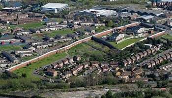
The peace lines or peace walls are a series of separation barriers in Northern Ireland that separate predominantly Republican and Nationalist Catholic neighbourhoods from predominantly Loyalist and Unionist Protestant neighbourhoods. They have been built at urban interface areas in Belfast, Derry, Portadown and elsewhere. The stated purpose of the peace lines is to minimise inter-communal violence between Catholics (most of whom are nationalists who self-identify as Irish) and Protestants (most of whom are unionists who self-identify as British).
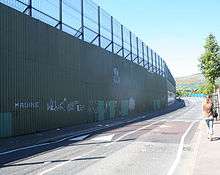
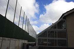
The peace lines range in length from a few hundred yards to over three miles (5 km). They may be made of iron, brick, and/or steel and are up to 25 feet (7.6 m) high. Some have gates in them (sometimes staffed by police) that allow passage during daylight but are closed at night.
The majority of peace walls are located in Belfast, but they also exist in Derry, Portadown, and Lurgan.[1]
History
The first peace lines were built in 1969, following the outbreak of the 1969 Northern Ireland riots and "the Troubles". They were built as temporary structures meant to last only six months, but due to their effective nature they have become wider, longer and more permanent. Originally few in number, they have multiplied over the years, from 18 in the early 1990s to at least 59 as of late 2017;[2] in total they stretch over 21 miles (34 km), with most located in Belfast. They have been increased in both height and number since the Good Friday Agreement of 1998.[3] Three-quarters of Belfast's estimated 99 peace lines and related structures (such as gates and closed roads) are in the north and west of the city.[4] These are also the poorer and more disadvantaged areas of Belfast. 67% of deaths during the sectarian violence occurred within 500 meters of one of these "interface structures".[5]
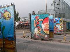
In recent years, they have even become locations for tourism. Black taxis now take groups of tourists around Belfast's peace lines, trouble spots and famous murals.
The most prominent peace lines in the past few years separate the nationalist Falls Road and unionist Shankill Road areas of West Belfast; the nationalist Short Strand from the unionist Cluan Place areas of East Belfast, the unionist Corcrain road and the nationalist Orbins drive in Portadown and the unionist Fountain estate and nationalist Bishop Street area of Derry.
In 2008, a public discussion began about how and when the peace lines could be removed.[6] While, on 1 September 2011, Belfast City Council agreed to develop a strategy regarding the removal of peace walls,[7][8] a study was released in 2012 indicating that 69% of residents believe that the peace walls are still necessary because of potential violence.[9] At the end of 2011, several local community initiatives resulted in the opening of a number of interface structures for a trial period.[10]
In January 2012, the International Fund for Ireland launched a Peace Walls funding programme to support local communities who want to work towards beginning to remove the peace walls.[11] In May 2013, the Northern Ireland Executive committed to the removal of all peace lines by mutual consent by 2023.[12]
In September 2017, the Northern Ireland Department of Justice published its Interface Programme, established to deliver the commitment made by the Northern Ireland Executive to remove all Interface structures by 2023 under the Together: Building a United Community Strategy.[13][14]
See also
References
- ↑ Peace Walls, Northern Ireland Foundation (last accessed April 4, 2017).
- ↑ "Department of Justice Interface Programme | Department of Justice". Justice. 2017-07-31. Retrieved 2017-11-01.
- ↑ Donaghy, Brendan (ed.). "Launch of North Belfast Peace Walls Project". Mediation Digest.
- ↑ "Interfaces Map | Belfast Interface Project". www.belfastinterfaceproject.org. Retrieved 2018-09-12.
- ↑ Murtagh, Brendan (2017). "Urban alternatives and collaborative economics in Belfast's contested space". The social ecology of border landscapes. Grichting, Anna, Zebich-Knos, Michele (editors). London: Anthem Press. pp. 181–194. ISBN 9781783086719. OCLC 985108699.
- ↑ Tony Macaulay (July 2008). "A Process for Removing Interface Barriers: A discussion paper proposing a five phase process for the removal of 'peace walls' in Northern Ireland" (PDF). Macaulay Associates. Retrieved 2010-02-06.
- ↑ "Belfast's peace walls may be set to tumble". The Irish Times. 3 September 2011. Archived from the original on 3 September 2011.
- ↑ "Belfast City Council agrees to act on peace walls". BBC. 2 September 2011. Retrieved 2 May 2013.
- ↑ "Peace Walls 'As Contentious As Ever'". Ulster Research. Retrieved 23 November 2012.
- ↑ McAdam, Noel (18 January 2012). "£2m to tear down Northern Ireland peace walls". Belfast Telegraph. Retrieved 2 May 2013.
- ↑ "Northern Ireland: Cash Boost For Plan To Bring Down Peace Walls". Huffington Post. 1 January 2012. Retrieved 2 May 2013.
- ↑ "Robinson and McGuinness want "peace walls" down within 10 years". The Irish Times. 10 May 2013. Retrieved 5 January 2014.
- ↑
- ↑
Further reading
- Belfast Interface Project (2 June 2017). Interface Barriers, Peacelines and Defensive Architecture, ISBN 978-0-9548819-5-5, Belfast 2017. Retrieved 30 September 2017
- Paul Brown (4 February 2002). "Peace but no love as Northern Ireland divide grows ever wider". The Guardian. Retrieved 6 February 2010.
- Margrethe C. Lauber. "Belfast's Peacelines: An Analysis of Urban Borders, Design and Social Space in a Divided City". mspacenyc.com. Archived from the original on 20 August 2008. Retrieved 6 February 2010.
- Tony Macaulay (July 2008). "A discussion paper proposing a five phase process for the removal of 'peace walls' in Northern Ireland" (PDF). Macaulay Associates. Retrieved 6 February 2010.
- Shawn Pogatchnik (3 May 2008). "Despite peace, Belfast walls are growing in size and number". USA Today. Retrieved 6 February 2010.
External links
- Peacewall Archive (An archive of photos, maps, texts and links relating to Belfast's Peacelines)
- Belfast Interface Project Interfaces Map (An interactive map locating all Interface barriers in Northern Ireland, surveyed in 2017)
- NI Department of Justice Interface Programme (established to deliver the commitment made by the Northern Ireland Executive to remove all Interface structures by 2023)
- Peace Lines
- Ethnic Interface in North Belfast
- Forty years of peace lines (BBC News web page detailing the various peace lines across Northern Ireland as of mid-2009)