Passagassawakeag River
| Passagassawaukeag River | |
|---|---|
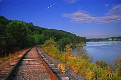 A moonlight view of the Passagassawaukeag River along the tracks of the Belfast and Moosehead Lake Railroad just beyond the old Upper Bridge a little more than a mile inland from Belfast, ME, where it empties into Belfast Bay. | |
| Country | United States |
| Physical characteristics | |
| Main source |
Lake Passagassawakeag Maine 308 feet (90 m) |
| River mouth |
Belfast Bay sea level 44°25′48″N 69°00′22″W / 44.430°N 69.006°WCoordinates: 44°25′48″N 69°00′22″W / 44.430°N 69.006°W |
The Passagassawaukeag River (/pæsəɡæsəˈwɑːkɛɡ,
The waterway's name is of local Indian origin and is believed to mean "a sturgeon's place" or "a place for spearing sturgeon by torchlight." [2]
.jpg)
A pair of late 1940's electric locomotives on the Belfast and Moosehead Lake Railroad, crossing the river heading inland from Belfast Bay.
References
- ↑ U.S. Geological Survey. National Hydrography Dataset high-resolution flowline data. The National Map, accessed June 22, 2011
- ↑ Fannie Hardy Eckstrom, Indian Place-Names of the Penobscot Valley and the Maine Coast; Univ of Maine Press; Orono, Maine 1974 (original 1941)
External links
| Wikimedia Commons has media related to Passagassawaukeag River. |
- "Passagassawakeag River". Geographic Names Information System. United States Geological Survey. 30 September 1980. Retrieved 2010-06-17.
This article is issued from
Wikipedia.
The text is licensed under Creative Commons - Attribution - Sharealike.
Additional terms may apply for the media files.