Paso de los Libres
| Paso de los Libres | |
|---|---|
| City | |
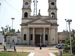 San José Church, Paso de los Libres | |
 Paso de los Libres Location of Paso de los Libres in Argentina | |
| Coordinates: 29°43′S 57°5′W / 29.717°S 57.083°WCoordinates: 29°43′S 57°5′W / 29.717°S 57.083°W | |
| Country |
|
| Province |
|
| Department | Paso de los Libres |
| Government | |
| • Mayor | Eduardo A. Vischi (Unión Cívica Radical) |
| Population (2010 census) | |
| • Total | 43,251 |
| Demonym(s) | libreño/a |
| Time zone | UTC-3 (ART) |
| CPA base | W3320 |
| Dialing code | +54 3772 |
Paso de los Libres is a city in the east of the province of Corrientes in the Argentine Mesopotamia. It had about 44,000 inhabitants at the 2001 census [INDEC], and is the head town of the department of the same name.
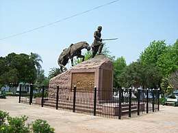
Monument to General Joaquín Madariaga and the 108 Valiants.
The city lies on the right-hand (western) shore of the Uruguay River, opposite the city of Uruguaiana, Rio Grande do Sul, Brazil, to which it is joined by a road and railway bridge (Paso de los Libres-Uruguaiana International Bridge). The area is served by Paso de los Libres Airport.
Climate
| Climate data for Paso de los Libres (1981–2010, extremes 1961–present) | |||||||||||||
|---|---|---|---|---|---|---|---|---|---|---|---|---|---|
| Month | Jan | Feb | Mar | Apr | May | Jun | Jul | Aug | Sep | Oct | Nov | Dec | Year |
| Record high °C (°F) | 42.1 (107.8) |
40.4 (104.7) |
39.5 (103.1) |
36.7 (98.1) |
34.4 (93.9) |
31.5 (88.7) |
31.4 (88.5) |
35.6 (96.1) |
36.4 (97.5) |
38.3 (100.9) |
41.6 (106.9) |
42.0 (107.6) |
42.1 (107.8) |
| Average high °C (°F) | 32.6 (90.7) |
31.0 (87.8) |
29.6 (85.3) |
25.6 (78.1) |
21.9 (71.4) |
19.2 (66.6) |
19.1 (66.4) |
21.6 (70.9) |
22.6 (72.7) |
25.9 (78.6) |
28.5 (83.3) |
31.2 (88.2) |
25.7 (78.3) |
| Daily mean °C (°F) | 26.2 (79.2) |
25.0 (77) |
23.6 (74.5) |
19.9 (67.8) |
16.3 (61.3) |
13.9 (57) |
13.4 (56.1) |
15.3 (59.5) |
16.7 (62.1) |
20.1 (68.2) |
22.5 (72.5) |
25.0 (77) |
19.8 (67.6) |
| Average low °C (°F) | 20.5 (68.9) |
20.0 (68) |
18.5 (65.3) |
15.2 (59.4) |
11.7 (53.1) |
9.7 (49.5) |
9.0 (48.2) |
10.3 (50.5) |
11.7 (53.1) |
14.7 (58.5) |
16.8 (62.2) |
19.0 (66.2) |
14.8 (58.6) |
| Record low °C (°F) | 10.2 (50.4) |
8.7 (47.7) |
5.8 (42.4) |
3.2 (37.8) |
−0.3 (31.5) |
−4.0 (24.8) |
−3.5 (25.7) |
−3.0 (26.6) |
0.2 (32.4) |
2.8 (37) |
6.0 (42.8) |
8.1 (46.6) |
−4.0 (24.8) |
| Average precipitation mm (inches) | 128.0 (5.039) |
154.3 (6.075) |
166.8 (6.567) |
205.0 (8.071) |
129.8 (5.11) |
101.4 (3.992) |
73.7 (2.902) |
56.8 (2.236) |
108.7 (4.28) |
152.6 (6.008) |
149.9 (5.902) |
120.6 (4.748) |
1,547.6 (60.929) |
| Average precipitation days (≥ 0.1 mm) | 7.1 | 8.5 | 7.7 | 8.6 | 7.4 | 8.0 | 6.7 | 5.9 | 7.7 | 9.1 | 7.7 | 6.9 | 91.3 |
| Average relative humidity (%) | 67.0 | 72.5 | 74.4 | 78.1 | 80.4 | 82.3 | 79.6 | 75.0 | 73.8 | 72.2 | 68.7 | 65.7 | 74.1 |
| Mean monthly sunshine hours | 238.7 | 206.2 | 179.8 | 174.0 | 176.7 | 132.0 | 130.2 | 151.9 | 120.0 | 192.2 | 216.0 | 220.1 | 2,137.8 |
| Percent possible sunshine | 56 | 56 | 47 | 51 | 54 | 43 | 40 | 45 | 34 | 48 | 52 | 50 | 48 |
| Source #1: Servicio Meteorologico Nacional[1][2] | |||||||||||||
| Source #2: UNLP (sun only)[3] | |||||||||||||
References
- ↑ "Estadísticas Climatológicas Normales - período 1981-2010" (in Spanish). Servicio Meteorológico Nacional. Retrieved January 20, 2018.
- ↑ "Clima en la Argentina: Guia Climática por Paso de los Libres Aero". Caracterización: Estadísticas de largo plazo (in Spanish). Servicio Meteorológico Nacional. Archived from the original on 4 September 2017. Retrieved 4 October 2017.
- ↑ "Datos bioclimáticos de 173 localidades argentinas". Atlas Bioclimáticos (in Spanish). Universidad Nacional de La Plata. Retrieved June 15, 2015.
- Municipal information: Municipal Affairs Federal Institute (IFAM), Municipal Affairs Secretariat, Ministry of Interior, Argentina. (in Spanish)
This article is issued from
Wikipedia.
The text is licensed under Creative Commons - Attribution - Sharealike.
Additional terms may apply for the media files.