Parry Street, Fremantle
| Parry Street Western Australia | |
|---|---|
| General information | |
| Type | Street |
| Length | 1.1 km (0.7 mi) |
| Major junctions | |
| North end | Beach Street |
| South end | South Terrace |
| Location(s) | |
| Suburb(s) | Fremantle |
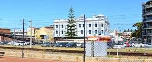
Parry Street is the street between the large buildings in the right of the photograph; Beach Street is the street in front of buildings to the left; Elder Place runs in front of the building on the right. Photograph taken from Peter Hughes Drive across the Fremantle Railway Line in the Victoria Quay part of Fremantle Harbour.
Parry Street is a street in Fremantle, Western Australia.
Its northernmost point is its junction with Elder Place and Beach Street.
The Fremantle Bowling club is located at the intersection with Ellen Street.[1]
Parry Street intersects with High Street at Queens Square.[2]
The Parry Street car park, south of the intersection with High Street is adjacent to the Fremantle Prison.[3]
The Fremantle branch of Legacy Australia is based at Legacy House, 17 Parry Street.[4] The Fly by Night Club was formerly located in the street.
Notes
- ↑ Orloff, Izzy; HRRC (1928), Fremantle Bowling Club opening, retrieved 22 November 2012
- ↑ "Queen's Square". State Heritage Office. Government of Western Australia. 23 December 2011. Retrieved 16 November 2012.
- ↑ McIlroy, Jack; Building Management Authority of Western Australia (1990), Fremantle Prison : conservation and future use : outside the walls : historical archaeological assessment of Parry Street Carpark, Building Management Authority of W.A, ISBN 978-0-7244-9696-9
- ↑ http://pandora.nla.gov.au/pan/144429/20160720-0030/www.legacy.com.au/fremantle/ContactFremantleLegacy.html
- Google (1 December 2012). "Parry Street, Fremantle" (Map). Google Maps. Google. Retrieved 1 December 2012.
Route map:
This article is issued from
Wikipedia.
The text is licensed under Creative Commons - Attribution - Sharealike.
Additional terms may apply for the media files.