Parry County

Parry
New South Wales
Location in New South Wales
Lands administrative divisions around Parry:
Nandewar Inglis Vernon
Buckland Parry Vernon
Buckland Brisbane Hawes

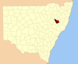
Parry County is one of the 141 Cadastral divisions of New South Wales. It is bounded by the Peel River and Cockburn River on the north, near Tamworth. The Moonbi Range is on the eastern boundary, and the Peel Range on the western boundary. The Great Dividing Range is the boundary to the south-east. It includes the towns of Dungowan, Woolomin, Piallamore and Nundle.

Parry County was named in honour of Sir William Edward Parry, Commissioner for the Australian Agricultural Company, who selected the area within the county which was granted to what was then called the Peel River Company.[1]

Parishes within this county

A full list of parishes found within this county; their current LGA and mapping coordinates to the approximate centre of each location is as follows:

ParishLGACoordinates
AinsleyTamworth Regional Council31°10′54″S 151°20′04″E / 31.18167°S 151.33444°E / -31.18167; 151.33444 (Ainsley)
AnnaTamworth Regional Council31°06′54″S 151°15′04″E / 31.11500°S 151.25111°E / -31.11500; 151.25111 (Anna)
BectiveTamworth Regional Council30°59′54″S 150°45′04″E / 30.99833°S 150.75111°E / -30.99833; 150.75111 (Bective)
BullimballTamworth Regional Council31°05′54″S 151°12′04″E / 31.09833°S 151.20111°E / -31.09833; 151.20111 (Bullimball)
CalalaTamworth Regional Council31°08′54″S 150°56′04″E / 31.14833°S 150.93444°E / -31.14833; 150.93444 (Calala)
CallaghanTamworth Regional Council31°20′54″S 151°24′04″E / 31.34833°S 151.40111°E / -31.34833; 151.40111 (Callaghan)
CrawneyTamworth Regional Council31°32′54″S 151°00′04″E / 31.54833°S 151.00111°E / -31.54833; 151.00111 (Crawney)
DungowanTamworth Regional Council31°25′54″S 151°10′04″E / 31.43167°S 151.16778°E / -31.43167; 151.16778 (Dungowan)
GarooTamworth Regional Council31°21′54″S 150°58′04″E / 31.36500°S 150.96778°E / -31.36500; 150.96778 (Garoo)
GillTamworth Regional Council31°07′50″S 151°05′35″E / 31.13056°S 151.09306°E / -31.13056; 151.09306 (Gill)
Goonoo GoonooTamworth Regional Council31°19′54″S 150°50′04″E / 31.33167°S 150.83444°E / -31.33167; 150.83444 (Goonoo Goonoo)
LoftusTamworth Regional Council31°14′54″S 151°20′04″E / 31.24833°S 151.33444°E / -31.24833; 151.33444 (Loftus)
LoomberahTamworth Regional Council31°14′54″S 150°59′04″E / 31.24833°S 150.98444°E / -31.24833; 150.98444 (Loomberah)
MoolunmoolaTamworth Regional Council31°03′54″S 150°40′04″E / 31.06500°S 150.66778°E / -31.06500; 150.66778 (Moolunmoola)
MoorowaraGunnedah Shire Council30°56′54″S 150°31′04″E / 30.94833°S 150.51778°E / -30.94833; 150.51778 (Moorowara)
MullaTamworth Regional Council31°07′24″S 151°08′04″E / 31.12333°S 151.13444°E / -31.12333; 151.13444 (Mulla)
MurroonTamworth Regional Council31°05′54″S 150°52′04″E / 31.09833°S 150.86778°E / -31.09833; 150.86778 (Murroon)
NeminghaTamworth Regional Council31°06′54″S 150°51′04″E / 31.11500°S 150.85111°E / -31.11500; 150.85111 (Nemingha)
NundleTamworth Regional Council31°29′54″S 151°08′04″E / 31.49833°S 151.13444°E / -31.49833; 151.13444 (Nundle)
OgunbilTamworth Regional Council31°18′24″S 151°16′54″E / 31.30667°S 151.28167°E / -31.30667; 151.28167 (Ogunbil)
PiallamoreTamworth Regional Council31°11′48″S 151°10′28″E / 31.19667°S 151.17444°E / -31.19667; 151.17444 (Piallamore)
RoyinnTamworth Regional Council31°21′54″S 151°15′04″E / 31.36500°S 151.25111°E / -31.36500; 151.25111 (Royinn)
ScottTamworth Regional Council31°24′54″S 151°21′04″E / 31.41500°S 151.35111°E / -31.41500; 151.35111 (Scott)
SomertonTamworth Regional Council31°01′08″S 150°37′31″E / 31.01889°S 150.62528°E / -31.01889; 150.62528 (Somerton)
TamarangTamworth Regional Council31°20′54″S 150°53′04″E / 31.34833°S 150.88444°E / -31.34833; 150.88444 (Tamarang)
TangarattaTamworth Regional Council30°58′54″S 150°49′04″E / 30.98167°S 150.81778°E / -30.98167; 150.81778 (Tangaratta)
TimbumburiTamworth Regional Council31°15′54″S 150°56′04″E / 31.26500°S 150.93444°E / -31.26500; 150.93444 (Timbumburi)
TuriTamworth Regional Council31°16′54″S 150°51′04″E / 31.28167°S 150.85111°E / -31.28167; 150.85111 (Turi)
VernonWalcha Council31°07′54″S 151°20′04″E / 31.13167°S 151.33444°E / -31.13167; 151.33444 (Vernon)
WalchaTamworth Regional Council31°15′54″S 151°21′04″E / 31.26500°S 151.35111°E / -31.26500; 151.35111 (Walcha)
WarralTamworth Regional Council31°09′54″S 150°46′04″E / 31.16500°S 150.76778°E / -31.16500; 150.76778 (Warral)
WintonTamworth Regional Council31°06′54″S 150°43′04″E / 31.11500°S 150.71778°E / -31.11500; 150.71778 (Winton)
WombramurraTamworth Regional Council31°34′43″S 151°06′03″E / 31.57861°S 151.10083°E / -31.57861; 151.10083 (Wombramurra)
WoolominTamworth Regional Council31°16′50″S 151°10′47″E / 31.28056°S 151.17972°E / -31.28056; 151.17972 (Woolomin)
YeerowinTamworth Regional Council31°25′54″S 151°18′04″E / 31.43167°S 151.30111°E / -31.43167; 151.30111 (Yeerowin)

See also

References

  1. "Parry". Geographical Names Register (GNR) of NSW. Geographical Names Board of New South Wales. Retrieved 7 August 2013.
This article is issued from Wikipedia. The text is licensed under Creative Commons - Attribution - Sharealike. Additional terms may apply for the media files.