Parhuayane
| Parhuayane | |
|---|---|
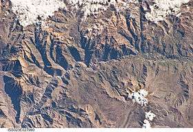 The Colca River and Parhuayane north of it as seen from the ISS | |
| Highest point | |
| Elevation | 5,100 m (16,700 ft) [1] |
| Coordinates | 15°29′09″S 71°51′44″W / 15.48583°S 71.86222°WCoordinates: 15°29′09″S 71°51′44″W / 15.48583°S 71.86222°W |
| Geography | |
 Parhuayane Peru | |
| Location | Peru, Arequipa Region |
| Parent range | Andes, Chila |
Parhuayane (possibly from Aymara parwaya a plant of the Deyeuxia family,[2] -ni a suffix to indicate ownership, "the one with the parwaya plant") is a mountain in the Chila mountain range in the Andes of Peru, about 5,100 m (16,700 ft) high. It is located in the Arequipa Region, Caylloma Province, Madrigal District. Parhuayane lies southeast of Minaspata and Surihuiri.[1]
References
- 1 2 escale.minedu.gob.pe - UGEL map of the Caylloma Province 1 (Arequipa Region)
- ↑ Jorge Araya-Presa, Francisco A. Squeo, Lina Barrientos, Eliana Belmonte, Manuel Mamani, Gina Arancio, Manual de Plantas y Canciones en Aymara, PROYECTO EXPLORA-CONICYT ED7/02/085: Etnobotánica y Etnomusicología Aymara: Divulgación de la sabiduría ancestral sobre plantas nativas del Altiplano de Arica, Chile, 2003. See: Kiña parwaya: Deyeuxia curvula
This article is issued from
Wikipedia.
The text is licensed under Creative Commons - Attribution - Sharealike.
Additional terms may apply for the media files.