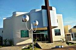
Paranaíba
| Paranaíba | |||
|---|---|---|---|
| Municipality | |||
| The Municipality of Paranaíba | |||
 | |||
| |||
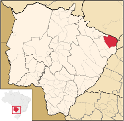 Location of Paranaíba | |||
| Coordinates: 19°40′37″S 51°11′27″W / 19.67694°S 51.19083°WCoordinates: 19°40′37″S 51°11′27″W / 19.67694°S 51.19083°W | |||
| Country |
| ||
| Region | Central-West | ||
| State |
| ||
| Founded | April 19, 1838 | ||
| Government | |||
| • Mayor | José Garcia de Freitas (Zé Braquiara) (PDT) | ||
| Area | |||
| • Total | 5,402.778 km2 (2,086.024 sq mi) | ||
| Elevation | 374 m (1,227 ft) | ||
| Population (2008) | |||
| • Total | 40,118 | ||
| • Density | 7.16/km2 (18.5/sq mi) | ||
| [1] | |||
| Time zone | UTC-4 (UTC-4) | ||
| • Summer (DST) | UTC-3 (UTC-3) | ||
| HDI (2000) | 0.772 – medium[2] | ||
| Website | www.paranaiba.ms.gov.br/ | ||


Paranaíba is the easternmost municipality in the Brazilian state of Mato Grosso do Sul. Its population was 40,118 (2008) and its area is 5,402.778 km².[3]
References
| Wikimedia Commons has media related to Paranaíba. |
This article is issued from
Wikipedia.
The text is licensed under Creative Commons - Attribution - Sharealike.
Additional terms may apply for the media files.