Pappenheim (state)
| Lordship (County) of Pappenheim Herrschaft (Grafschaft) Pappenheim | |||||||||
|---|---|---|---|---|---|---|---|---|---|
| 1030–1806 | |||||||||
 Coat of arms
| |||||||||
| Status | State of the Holy Roman Empire | ||||||||
| Capital | Pappenheim | ||||||||
| Government | Principality | ||||||||
| Historical era | Middle Ages | ||||||||
• Lordship founded | ca 1030 | ||||||||
• Partitioned in four | 1439 | ||||||||
• Partitioned in twain | 1558 | ||||||||
• Raised to county | 1628 | ||||||||
|
1629 | |||||||||
| 1806 | |||||||||
| |||||||||
Pappenheim was a German statelet in western Bavaria, Germany, located on the Altmühl river between Treuchtlingen and Solnhofen, and south of Weißenburg.
History
Pappenheim originated as a Lordship around 1030, and was raised to a county in 1628.
The first member of the House of Pappenheim was Henricus Caput, mentioned in 1111 as vassal of Henry V, Holy Roman Emperor. From about 1100 until 1806 the Lords and Counts of Pappenheim held the position of hereditary marshals of the Holy Roman Empire, a court office that made them deputies of the Empire's arch marshals, the Electors of Saxony, with certain ceremonial tasks at the Coronation of the Holy Roman Emperor.
Pappenheim was partitioned twice: between itself, Alesheim (Aletzheim), Gräfenthal and Treuchtlingen in 1439; and between itself and Stühlingen in 1558. Pappenheim absorbed: Alesheim 1697; Gräfenthal 1536; and Treuchtlingen 1647. Treuchtlingen was purchased in 1447/53 and, after the Treuchtlingen branch extinguished in 1647, became part of the Principality of Ansbach. Stühlingen, acquired in 1582, was inherited by Fürstenberg in 1639. Pappenheim was mediatised to Bavaria in 1806. Was not a member of the Imperial Diet; recognised by Bavaria as a mediatised house in 1831.
Heads of state
Lords of Pappenheim (c. 1030–1628)

- Henry I (c. 1030–?)
- Henry II
- Henry III
- Ernest (?–1170)
- Henry I (1170–93)
- Rudolph I (1193–1221)
- Frederick (1221–40) with...
- Rudolph II (1221–33)
- Henry III (1240–78)
- Henry IV (1278–1318)
- Rudolph I (1313–35)
- Rudolph II (1335–45)
- Henry V (1345–87)
- Haupt I (1387–1409)
- Haupt II (1409–39) with...
- Sigismund (1409–36)
- Henry (1439–82)
- William (1482–1508)
- Joachim (1508–36)
- Wolfgang I (1536–58)
- Christopher (1558–69) with...
- Philip (1558–19) and...
- Wolfgang II (1558–85) and...
- Wolfgang Christopher (1585–1628)
Counts of Pappenheim (1628–1806)
- Wolfgang Christopher (1628–35)
- Wolfgang Philip (Count of Aletzheim) (1628–71)
- Charles Philip Gustav (1671–92)
- Louis Francis (1692–97)
- Christian Ernest (Count of Aletzheim) (1697–1721) with...
- John Frederick (Count of Aletzheim) (1697–1731) and...
- Frederick Ernest (1721–25) and...
- Albert Louis Frederick (1725–33)
- Frederick Ferdinand (1733–73)
- John Frederick Ferdinand (1773–92)
- Charles Theodore Frederick Eugene Francis (1792–1806)
- Frederick William (regent) (1792–97)
After German Mediatization
- Karl Theodor (Charles Theodore), Count 1792-1853 (1771-1853)
- Albert, Count 1853-1860 (1777-1860)
- Ludwig, Count 1860-1883 (1815-1883) (Lutheran branch)
- Maximilian, Count 1883-1890/1 (1860-1920) - renounced his rights 1890/1
- Ludwig, Count 1890/1-1905 (1862-1905)
- Ludwig, Count 1905-1960 (1898-1960), owner of Pappenheim
- Countess Ursula, heiress of Pappenheim ∞ Count Gert von der Recke von Volmerstein (1921–1991)
- Countess Iniga von der Recke von Volmerstein (b. 1952) ∞ Count Albrecht von Egloffstein (b. 1946)
- Countess Ursula, heiress of Pappenheim ∞ Count Gert von der Recke von Volmerstein (1921–1991)
- Ludwig, Count 1905-1960 (1898-1960), owner of Pappenheim
- Count Alexander (1819-1890), owner of Iszkaszentgyörgy Castle, Hungary (Roman catholic branch)
- Count Siegfried (1868-1936)
- Alexander, Count 1960-1995 (1905-1995)
- Albert, Count 1995–present (b.1943)
- Count Georg (1909-1986)
- Count Alexander (b.1948)
- Count Georg (b.1981)
- Count Alexander (b.1948)
- Alexander, Count 1960-1995 (1905-1995)
- Count Siegfried (1868-1936)
- Ludwig, Count 1860-1883 (1815-1883) (Lutheran branch)
Gallery
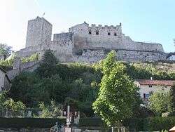 Pappenheim, the Old Castle of 1140
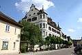 Pappenheim, the castle of 1593
 Pappenheim, the New Palace of 1819
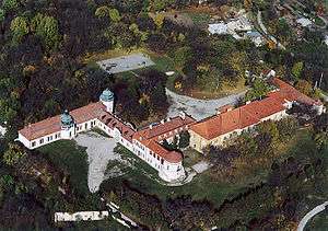 Iszkaszentgyörgy Palace, Hungary
See also
| Authority control |
|---|
References