Paposo
| Paposo | ||
|---|---|---|
| Town | ||
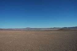
 The fog oases of Paposo | ||
| ||
| Coordinates: 25°00′30″S 70°27′53″W / 25.00833°S 70.46472°W | ||
| Elevation | 100 ft (30 m) | |
| Population | ||
| • Total | 259 | |

Coordinates: 25°00′30″S 70°27′53″W / 25.00833°S 70.46472°W Paposo or Caleta Paposo is a hamlet in the southern part of Antofagasta Province, Chile. Paposo is on the coast of the Pacific Ocean. The census of 2002 counted 259 inhabitants.[1]The inhabitants of Paposo rely on fishing and mining for a living.[2]
Paposo is best known for its unusual desert climate featuring frequent wet fog (garúa) and the "fog oases" which exist on mountain slopes of the Chilean Coast Range a few kilometers inland. In a region almost devoid of vegetation, the fog oases, also called lomas, support a variety of flora and fauna.
Geography and climate
Paposo is located adjacent to a small cove on the coast of the Pacific in the Atacama desert, the driest non-polar desert in the world.[3] Vegetation is nearly absent in most of the Atacama. At Paposo, the Andes foothills rise steeply inland from the sea reaching an elevation of 700 metres (2,300 ft) less than 2 kilometres (1.2 mi) from the coast.[4]
Paposo and the Atacama have the BWn climate in the Köppen Classification, characterized by mild temperatures, unusual in desert climates, and frequent fog rolling in from the nearby ocean, especially in the southern hemisphere winter. Average temperatures in Paposo range from 13.4 °C (56.1 °F) in July to 20 °C (68 °F) in January, the warmest month.[5] Annual precipitation is 16 millimetres (0.63 in). July is the month with most precipitation with 4 millimetres (0.16 in).[6]

The climatic feature which permits the growth of vegetation on the slopes of the mountains rising above Paposo is the garúa or camanchaca -- cloud banks caused by the cold waters of the Humboldt Current running offshore in the Pacific. Inland, on mountain slopes, the cloud banks form. The camanchaca, as it is called in Chile, is a dense fog that does not produce rain.[7] The moisture that makes up the cloud measures between 1 and 40 microns across, too fine to form rain droplets. Water condenses out of the fog to provide moisture for vegetation.[8]
The fog oasis
Near Paposo the camanchaca fog impacts elevations from 200 metres (660 ft) to 1,000 metres (3,300 ft) and up to about 7 kilometres (4.3 mi) inland from the ocean. Elevations between 400 metres (1,300 ft) and 700 metres (2,300 ft) receive the most moisture from the fog and have the most abundant vegetation. The quebradas (ravines) near Paposo sometimes have running water originating at higher elevations receiving greater precipitation.[9]
The fog oasis at Paposo has more plant species than any other fog oasis in Chile, counting at least 250 species of vascular plants.[10]
Wildlife in the fog oasis includes the guanaco and two species of foxes, the culpeo (Andean fox) and the South American gray fox.[11]
In 2013, the government of Chile, created the "Natural Monument of North Paposo" (Monumento Natural Paposo Norte) with an area of 7,915 hectares (19,560 acres). The Natural Monument is entered 2 kilometres (1.2 mi) east of the town of Paposo along both sides of highway B-710.[12] The Monument was formerly called the "Reserva Nacional Paposo."
Paranal
Paposo is the nearest community to the Paranal Observatory, the second largest observatory in the world. The observatory is located on Paranal mountain about 38 kilometres (24 mi) in straight-line distance north of Paposo. The observatory is located about 13 kilometres (8.1 mi) from the sea and at an altitude of 2,635 metres (8,645 ft), thus outside the area influenced by the camanchaca fog.[13]
References
- ↑ Ciudades, pueblos, aldeas y caserios" (2005), Santiago, Chile: Ediciones UNE, p. 141
- ↑ "La Flora de Quebrada de Paposo", http://www.chileflora.com/Florachilena/FloraSpanish/SHFloraPaposo.htm, accessed 7 Aug 2017
- ↑ "Yungay - the driest place in the world | Wondermondo". www.wondermondo.com. Retrieved 2017-05-06.
- ↑ Google Earth
- ↑ "Paposo, Antofagasta (Chile), https://www.yr.no/place/Chile/Antofagasta/Paposo/statistics.html, accessed 8 Aug 2017
- ↑ "Paposo", https://en.climate-data.org/location/148947/, accessed 8 Aug 2017
- ↑ Vesilind, Priit J. (2003). "The Driest Place on Earth". National Geographic. Retrieved 12 September 2013.
- ↑ Lavars, Nick (August 25, 2015). "How Chile's fogcatchers are bringing water to the driest desert on Earth". www.gizmag.com. Retrieved 2015-08-25.
- ↑ http://www.chileflora.com/Florachilena/FloraSpanish/SHFloraPaposo.htm
- ↑ Veblen, Thomas T., Young, Kenneth R., Orme, Anthony R. (2015), The Physical Geography of South America, Oxford: Oxford University Press, p. 168
- ↑ http://www.chileflora.com/Florachilena/FloraSpanish/SHFloraPaposo.htm
- ↑ "Monumento Natural Paposo Norte, http://www.conaf.cl/parques/monumento-natural-paposo-norte/, accessed 8 Aug 2017
- ↑ Google Earth