Papakowhai
Coordinates: 41°06′47″S 174°52′05″E / 41.113°S 174.868°E
| Papakowhai | |
|---|---|
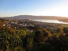 A view from the north-east: Porirua Harbour to the right, Porirua city centre and Colonial Knob ridge in the background. | |
| Basic information | |
| Local authority | Porirua City Council |
| Electoral ward | Northern [1] |
| Population | 2,460[2] (2006) |
| Postcode(s) | 5024 |
| Surrounds | |
| Northeast | Paremata [3] |
| East | Ascot Park |
| South | Aotea |
| Northwest | (Porirua Harbour) |
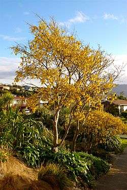
Kowhai tree in bloom at Papakowhai School
Papakowhai, a suburb of Porirua City, lies approximately 22 km north of Wellington in New Zealand.
The name "Papakowhai" (Māori pronunciation: [papaˈkɔfai]) in the Māori language means "yellow earth". As well as being the name of the suburb it is the name of the main road connecting the suburb to the south. Most of the other streets in Papakowhai take their names from Scottish rivers.
The first European known to have settled in the area was William Bowler in the early 19th century.
As of 2016 Papakowhai hosts a primary school, the Royal New Zealand Police College, Aotea Lagoon public park
Notes
External links
References
- Porirua City Council. "Porirua City Boundary, Suburban Areas and Wards Map". Porirua City Council. Retrieved 2013-05-14.
- Statistics New Zealand (2006). "QuickStats About Papakowhai". Statistics New Zealand. Retrieved 2013-05-14.
- Porirua City Council. "Porirua City Boundary and Suburban Areas Map". Porirua City Council. Retrieved 2013-05-14.
This article is issued from
Wikipedia.
The text is licensed under Creative Commons - Attribution - Sharealike.
Additional terms may apply for the media files.