Pantydwr railway station
| Pantydwr | |
|---|---|
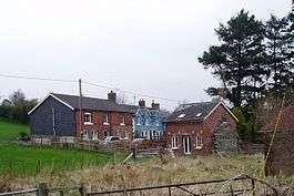 Old railway station at Pant y Dwr | |
| Location | |
| Place | North of St Harmon |
| Area | Powys |
| Coordinates | 52°21′40″N 3°29′41″W / 52.3611°N 3.4948°WCoordinates: 52°21′40″N 3°29′41″W / 52.3611°N 3.4948°W |
| Grid reference | SN982747 |
| Operations | |
| Original company | Mid-Wales Railway |
| Pre-grouping | Cambrian Railways |
| Post-grouping | Great Western Railway |
| History | |
| 1864 | Opened[1] |
| 1962 | Closed[1] |
| Disused railway stations in the United Kingdom | |
|
Closed railway stations in Britain A B C D–F G H–J K–L M–O P–R S T–V W–Z | |
|
| |
Pantydwr railway station was a station to the north of St Harmon, Powys, Wales. The station was opened in 1864.[1] The station was built at the highest point on the Mid-Wales Railway's line at 974 ft (297 m) above sea level.[1]
References
- 1 2 3 4 "The Railway". St Harmon Community Council. Retrieved 8 March 2017.
Further reading
- Mitchell, Vic; Smith, Keith (2003). Brecon to Newtown. Middleton Press. figs. 85-87. ISBN 9781906008062. OCLC 288983659.
| Preceding station | Disused railways | Following station | ||
|---|---|---|---|---|
| Glan-yr-Afon Halt Line and station closed |
Great Western Railway Mid-Wales Railway |
St Harmons Line and station closed | ||
This article is issued from
Wikipedia.
The text is licensed under Creative Commons - Attribution - Sharealike.
Additional terms may apply for the media files.