Panola, Oklahoma
| Panola | |
|---|---|
| Unincorporated community | |
 Panola Location within the state of Oklahoma  Panola Panola (the US) | |
| Coordinates: 34°55′43″N 95°12′48″W / 34.92861°N 95.21333°WCoordinates: 34°55′43″N 95°12′48″W / 34.92861°N 95.21333°W | |
| Country | United States |
| State | Oklahoma |
| County | Latimer |
| Time zone | UTC-6 (Central (CST)) |
| • Summer (DST) | UTC-5 (CDT) |
Panola is a small unincorporated community in Latimer County, Oklahoma, United States. The post office was established March 18, 1911. Panola is the Choctaw name for "cotton". The high school and gymnasium are on the National Register of Historic Places.
External links
- Panola Public School District Website
- Oklahoma Digital Maps: Digital Collections of Oklahoma and Indian Territory
Municipalities and communities of Latimer County, Oklahoma, United States | ||
|---|---|---|
| City | 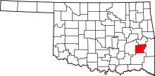 | |
| Towns | ||
| Unincorporated communities | ||
| Footnotes | ‡This populated place also has portions in an adjacent county or counties | |
This article is issued from
Wikipedia.
The text is licensed under Creative Commons - Attribution - Sharealike.
Additional terms may apply for the media files.