Panoche Hills
| Panoche Hills | |
|---|---|
 location of Panoche Hills in California[1] | |
| Highest point | |
| Elevation | 675 m (2,215 ft) |
| Geography | |
| Country | United States |
| State | California |
| District | Fresno County |
| Range coordinates | 36°38′40.828″N 120°43′54.641″W / 36.64467444°N 120.73184472°WCoordinates: 36°38′40.828″N 120°43′54.641″W / 36.64467444°N 120.73184472°W |
| Parent range | Diablo Range |
| Topo map | USGS Chounet Ranch |

Day transitioning to evening in the Panoche Hills. December 2015.
The Panoche Hills are a low mountain range in the Southern Inner California Coast Ranges System, in western Fresno County, California.[1]
They are east of the Diablo Range, on the west side of the San Joaquin Valley. They define the eastern side of the Panoche Valley.
Parks
Panoche Hills Recreation Area
The US Bureau of Land Management (BLM) maintains the Panoche Hills Recreation Area, a recreation area within the hills.[2] The entrance to the BLM area is across Little Panoche Road from the Mercey Hot Springs resort.[2]
Panoche Hills Ecological Reserve
The California Department of Fish and Game also maintains the Panoche Hills Ecological Reserve, an ecological reserve within the hills.[3]
Natural history
The Hills contain examples of fossilized remains of Mesozoic era cold seeps.[4]
See also
- Panoche Pass
- Panoche Valley
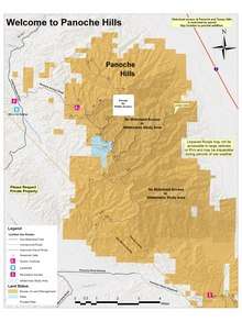 Panoche Hills Map with road labels
References
- 1 2 "Panoche Hills". Geographic Names Information System. United States Geological Survey. Retrieved 2009-05-04.
- 1 2 "Panoche Hills". Retrieved 2012-09-10.
- ↑ "DFG - Lands - Ecological Reserves - Central Region - Panoche Hills Ecological Reserve". Retrieved 2012-09-10.
- ↑ Schwartz, Hilde; Moore, J. Casey (3 April 2004). "A Paleocene Cold Seep System in the Panoche Hills, California" (pdf). Retrieved 2012-09-10.
This article is issued from
Wikipedia.
The text is licensed under Creative Commons - Attribution - Sharealike.
Additional terms may apply for the media files.