Pandar
| Pandar پندر | |
|---|---|
| village | |
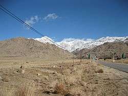 Pandar village. | |
 Pandar | |
| Coordinates: 31°28′20″N 54°10′58″E / 31.47222°N 54.18278°ECoordinates: 31°28′20″N 54°10′58″E / 31.47222°N 54.18278°E | |
| Country |
|
| Province | Yazd |
| County | Taft |
| Bakhsh | Nir |
| Rural District | Zardeyn |
| Population (2006) | |
| • Total | 330 |
| Time zone | UTC+3:30 (IRST) |
| • Summer (DST) | UTC+4:30 (IRDT) |
Pandar (Persian: پندر; also known as Panj Dar)[1] is a village in Zardeyn Rural District, Nir District, Taft County, Yazd Province, Iran. As of the 2006 census, its population was 330 across 92 families.[2] Pandar is on the eastern slopes of Shirkooh Mountain.
Name origin
According to some villagers, the name of Pandar has been derived from five large valley that have surrounded the whole village.
Religion
Shia Islam is the dominant religion in Pandar village. There are around five mosques in Pandar which mass mosque is the main one that people say their prayers there most of the time.
References
| Wikimedia Commons has media related to Pandar. |
- ↑ Pandar can be found at GEOnet Names Server, at this link, by opening the Advanced Search box, entering "-3761042" in the "Unique Feature Id" form, and clicking on "Search Database".
- ↑ "Census of the Islamic Republic of Iran, 1385 (2006)". Islamic Republic of Iran. Archived from the original (Excel) on 2011-11-11.
This article is issued from
Wikipedia.
The text is licensed under Creative Commons - Attribution - Sharealike.
Additional terms may apply for the media files.