Palaui Island Protected Landscape and Seascape
| Palaui Island Protected Landscape and Seascape | |
|---|---|
|
IUCN category V (protected landscape/seascape) | |
 Palaui Island, the main geographic feature of the protected area. | |
.svg.png) .svg.png) | |
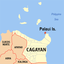
| Location | Santa Ana, Cagayan, Philippines |
| Coordinates | 18°32′46″N 122°8′11″E / 18.54611°N 122.13639°ECoordinates: 18°32′46″N 122°8′11″E / 18.54611°N 122.13639°E |
| Area | 8,048.57 hectares (19,888.4 acres) |
| Established | August 16, 1994 |
| Governing body | Department of Environment and Natural Resources |
The Palaui Island Protected Landscape and Seascape is a protected area and national park in the town of Santa Ana in Cagayan, Philippines. It is located off the northeastern extremity of Luzon Island, the largest island in the country.
Geography
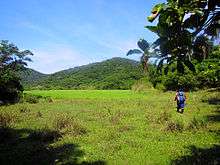
Palaui Island lies off the northwestern part of a large promontory in San Vicente, in the municipality of Santa Ana, Cagayan province. It is 10 kilometres (6.2 mi) at its longest and about 5 kilometres (3.1 mi) at its widest and moderately high. The western shore of the island appears bold, but on the eastern side, a reef projects from its side for 2.4 kilometres (1.5 mi), the edge of it being 0.8 kilometres (0.50 mi) from and extending around the small islet of Escucha, east of Palaui. The Dos Hermanos rocky islets lie off Cape Engaño, in the northern point of Palaui, and there are some rocks off the northeast point of the island, about 1.6 kilometres (0.99 mi) eastward of the cape. Gran Laja island, a low rock islet surrounded by breakers, is one of the rocks located northeast off Palaui.[1][2]
At the southwest end of Palaui Island is Puerto Point, a high, wooded bluff. East of the point and south of Palaui is Rona Island, a low, wooded island with a white base of sand and rocks. Escucha Island is a high and wooded islet east of Palaui, and beyond Rona Island when seen from southwestward through the channel between Palaui Island and the mainland, where a few more islets are located.[1]
Flora and fauna
Palaui Island was declared as a National Marine Reserve in August 28, 1994 encompassing an area of 7,145 hectares (17,660 acres).[3] The waters around the island boast of 21 commercial species of fishes with about 50 hectares (120 acres) of undisturbed corals.
Because of its remoteness, Palaui Island is home to 105 species of rattan and similar commercially valuable timber producing wood species plus 25 imported shrubs and is the sanctuary for 90 migratory birds.[4]
Tourism
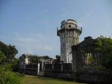
Among the destinations in the Palaui is the northern point of the island is the Cape Engaño Lighthouse which is situated at Cape Engaño the northern point of the island[5] and its beaches. The island is the tenth entry in CNN's World's 100 Best Beaches list which was published on May 13, which remarked the island's "raw beauty"[6]
On June 22, 2018, the Palaui Island Protected Landscape and Seascape was designated a national park through the Expanded National Integrated Protected Areas System (ENIPAS) Act or Republic Act No. 11038 which was signed by President Rodrigo Duterte.[7]
Transportation
The Port of San Vicente in the Cagayan mainland serves residents and tourist going to or departing from Palaui Island. Docking areas in Palaui is Punta Verde and the coastline of Engaño Cove.[8]
In popular culture
In 2013, it was used as the filming location for Survivor: Blood vs. Water and Survivor: Cagayan.
See also
References
- 1 2 U.S. Coast and Geodetic Survey. "United States Coast Pilot, Part 1", pp. 44-45. Washington Government Printing Office, 1919.
- ↑ Peters, Jens. "Philippines Travel Guide, 2nd edition", p.368. Jens Peters Publications, 2005. ISBN 3-923821-32-8.
- ↑ "Protected Areas in Region 2". Protected Areas and Wildlife Bureau of the Philippines. Retrieved on 2011-04-12.
- ↑ Lactaoen, Vic Albornoz (2009-12-17). "Palaui Island's Cape Engaño Lighthouse" Archived 2011-09-01 at the Wayback Machine.. Travels with Vic. Retrieved on 2011-04-12.
- ↑ "Cagayan: On rough seas to Palaui Island and Cape Engaño Lighthouse". En Route - Ironwulf.net. Retrieved on 2011-03-12.
- ↑ http://edition.cnn.com/2013/05/28/travel/100-best-beaches/index.html
- ↑ "New law declares 5 Cagayan Valley's protected areas as national parks". Philippine Information Agency. 7 August 2018. Retrieved 10 August 2018.
- ↑ Moymoy (2007). "Cape Engaño Lighthouse". Waypointsdotph. Retrieved on 2011-04-10.